Welcome
This guide is designed to assist you in getting started with your new HX-2+ so that you can explore ASAP.
Please note that the user guide you are currently reading may be updated periodically to reflect new features or changes in functionality within the HX-2+.
While we strive to ensure that the information contained herein is accurate and helpful, if you encounter any issues or feel that a topic requires further explanation, please do not hesitate to contact our Tech Support by submitting a ticket at https://kb.hemamaps.com/kb-tickets/new.
Hema Maps Cloud
The Hema Maps Cloud is a great complement to using the HX-2+. You can access the cloud at the following URL: http://cloud.hemamaps.com
You'll be asked to create a user account when you set up your device for the first time. You can log in to the Cloud using those details if you already have an account. If you still need to create an account, you can do so from the HX-2+ or directly on the Cloud site.
Why should you create a Cloud account?
- Well, for starters, it's free and extends the capabilities of the HX-2+. If you create an account and sign in from the app, your data, including waypoints, tracks, and trips, will be synced to the Cloud. This way, you'll always have a backup of your data if your device is lost or stolen
- Moreover, you're signed in to the same Cloud account if you use multiple devices, including the HX-2+ or a device running the Hema 4x4 Explorer App. In that case, your data will be synced automatically between devices.
- Lastly, you can share your data with friends and family members or make it public for the benefit of others if you so desire.
Getting Help
Hema Maps has created a Technical Support website to provide assistance and answer queries related to the use of our products.
The website contains Tech Support Knowledge Base, which includes various how-to guides and articles categorised to make locating the information you're looking for easier.
You can also use the search function to find answers quickly. You can access the Tech Support Knowledge Base at this URL: http://kb.hemamaps.com.
Technical Support Ticket System
Moreover, you can submit an enquiry related to any of Hema Map's products or services using the Technical Support Ticket System.
Once you submit a ticket, the system assigns a case number to your enquiry, and the Technical Support team will respond to you via email.
You can access the Tech Support Ticket System at this URL: https://kb.hemamaps.com/kb-tickets/new.
Tips for using the Tech Support Ticket System:
When submitting a support ticket, we advise you to search our Knowledge Base, as it may have the answers to your questions. However, if you still need to submit a ticket, please provide as much information as possible about the issue you are experiencing.
This will significantly assist us in troubleshooting your problem and finding a solution. Please avoid vague statements like "My HX-2+ isn't working" and provide specific details about your issue.
Switching the HX-2+ on and off
Switching on:
Press the power button for 2 seconds and release; an animation will display, followed by the main screen.
Switching off:
The HX-2+ can be completely switched off or put into Sleep Mode. Pressing the power button for 2 seconds will display a confirmation page asking you to “Power off” or “Restart”. Select “Power off” to completely switch the HX-2+ off.
1. Turning on the HX-2+
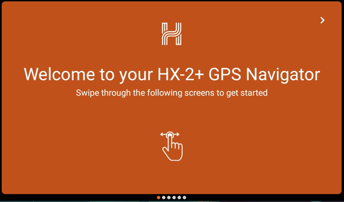
After starting the HX-2+, you will receive informative slides introducing the device's various features. Use the arrows or swipe to navigate through these slides.
Connecting to WiFi
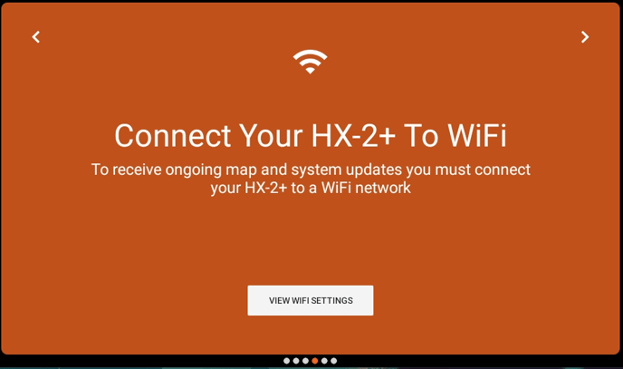
One of the informative slides provides information about WiFi.
While the HX-2+ can navigate offline, connecting the device to WiFi during initial installation is essential. This ensures your HX-2+ is set up correctly and allows you to navigate confidently. It's also recommended to regularly connect your device to WiFi to check for software, map updates and data sync.
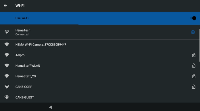
To connect to WiFi:
- Tap the "View WiFi Settings" button to open the WiFi page
- Tap your chosen WiFi network.
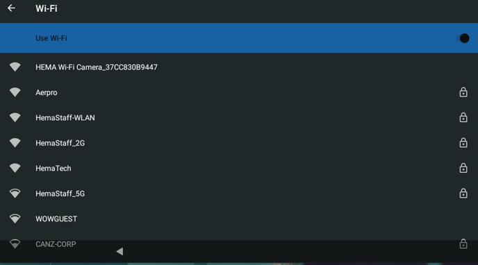
- Enter your password and tap "Connect".
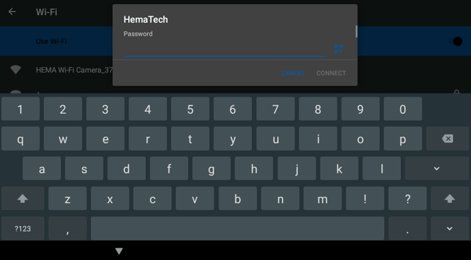
- Check if the HX-2+ has successfully connected to the WiFi. If it has, tap the back arrow in the top left corner.
2. Signing In / Creating an Account
On the following slide, you will be prompted to register your device. Registering your device is vital for several reasons:
- It enables you to enjoy three years of gold membership, giving you exclusive benefits.
- It allows our dedicated technical support team to assist whenever needed. Also, it enables us to reach out to you in case your device is ever lost or stolen.
- Registration also lets you synchronise your data with the Hema Maps Cloud, ensuring your valuable information is securely stored and easily accessible whenever needed.
You will find two sections on the registration page: "Existing members" and "New members".
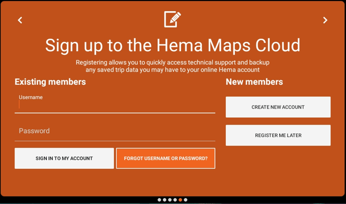
Existing Users
You can simply sign in using your existing login details if you have previously registered an account on the:
- HX-2
- 4x4 Explorer mobile application
- Hema Maps Cloud (2020)
If you have forgotten your username or password, you can easily recover it by tapping "Forgot username or password?". Just provide the email address you used when creating your account, and you will receive instructions to reset your password.
.png?width=688&height=403&name=Image%20from%20Chat%20(2).png)
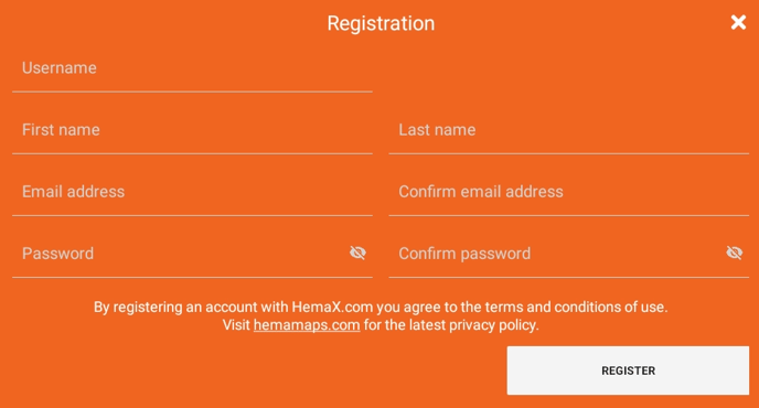
New Users
You must create a new account if this is your first Hema Maps digital product or you are transitioning from the:
- HX-1
- HN Series
- Hema Explorer mobile application
- 4WD Maps mobile application
This is because we have moved our Cloud service to a new platform to support our improved maps.
Tapping "Create new account" gives you a form to fill out. We recommend you use an easy-to-remember username and password and enter an email address you can always access. Submit this form by tapping "Register".
Afterwards, you'll be taken to the HX-2+ home screen.
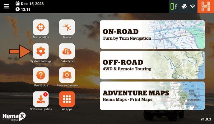
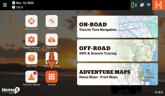
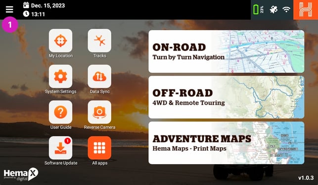
The Main Screen
This guide provides a brief description of the information displayed on the main screen after your HX-2+ boots up. For more detailed information, please refer to the relevant sections.
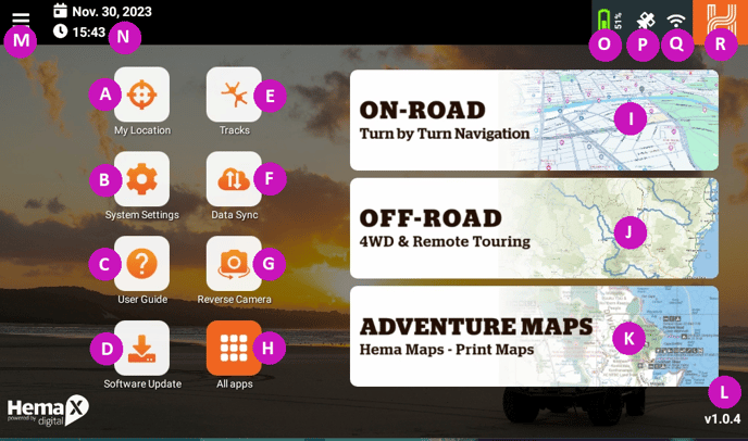
- A - My Location: Opens the My Location page
- B - System Settings: Opens the System settings page
- C User Guide: Opens the User Guide
- D Software Updates - Click to open the Software updates page
- E Tracks - Click to open the Tracks page
- F Data sync - Click to open the Data Sync page
- G Reversing Camera - Click to open the optional Reversing Camera page
- H All Apps - Click to open the Apps page
- I On-Road - Turn by Turn Navigation
- J Off-Road - 4WD & Remote Touring
- K Adventure Maps - Hema Print Maps
- L Version Number - Your current version
- M Main Menu - Including trips, tracks, routes, etc
- N Date and Time - Shows the date and time
- O Battery indicator - Shows the battery percentage
- P Satellite Status - Click to open the Satellite Status page
- Q Wi-Fi indicator - Click to open the Wi-Fi page
- R Navigation Button - Click once to go back a page, hold to return to the main screen
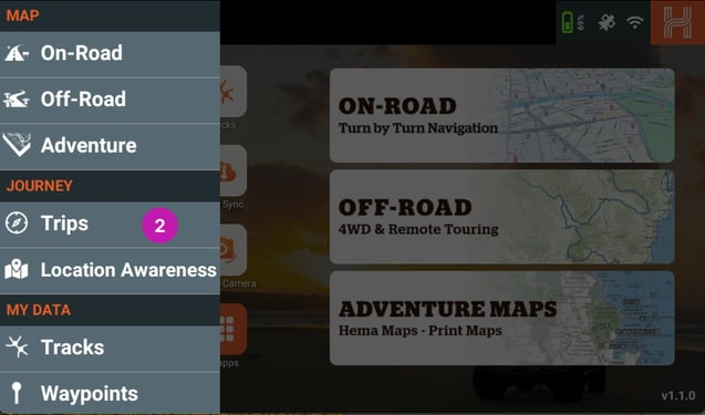
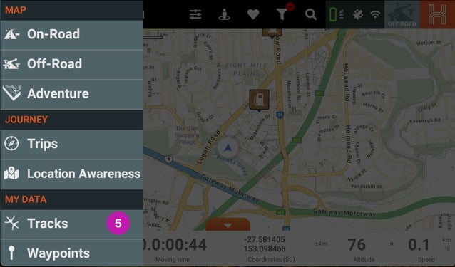
Main Menu
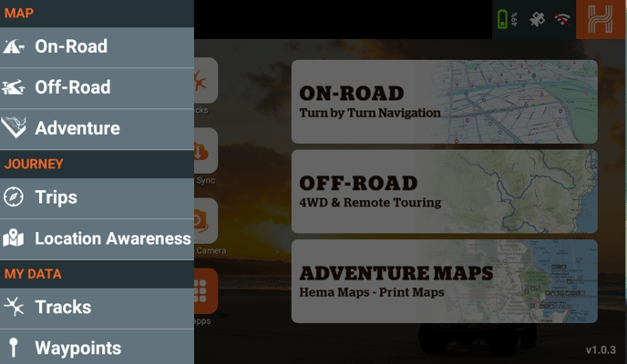
- On-Road - click to enter On-Road mode.
- Off-road - click to enter Off-road mode.
- Adventure - click to enter Adventure Maps mode.
- Trips - you can add and edit your trip plans here.
- Tracks - you can create and edit your Tracks here.
- Waypoints - you can create and edit your Waypoints here.
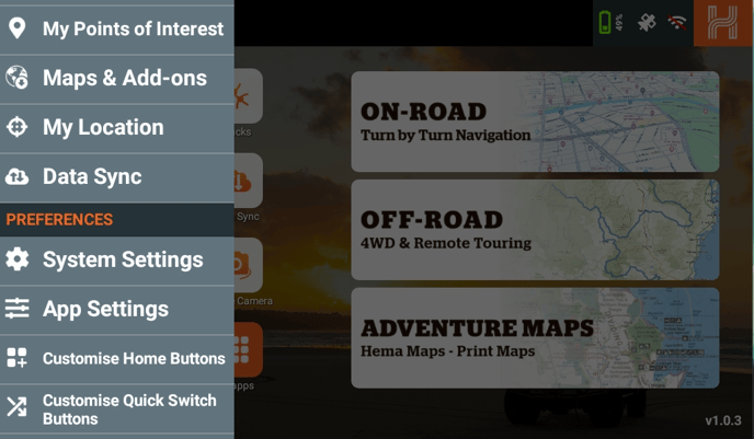
- My Points of Interest - you can create and edit your “My Points of Interest.”
- Maps & Add-ons - you can see your Map Subscriptions and download maps for adventure mode and your add-ons.
- My Location - this loads the My Location page.
- Data Sync - this loads the Data sync page.
- System Settings - this loads the System Settings page.
- App Settings - this loads the Data sync page.
- Customise Home Buttons - This allows you to change the icons on the home page.
- Customise Quick Switch - This allows you to change the quick switch options.
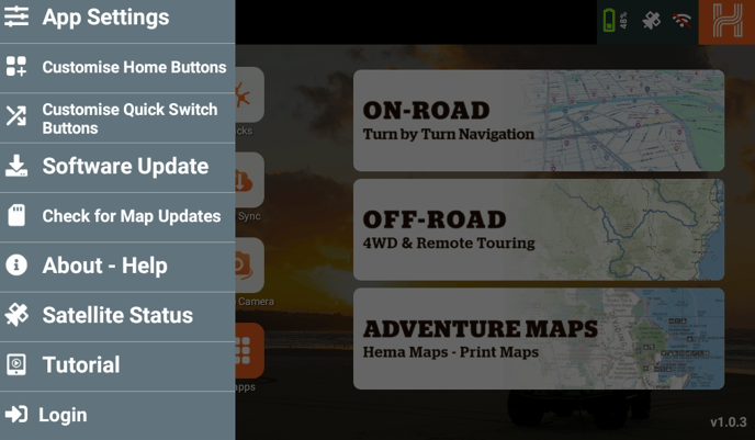
- Software Updates - this loads the Software updates page.
- Check for Map Updates- this loads the map update page.
- About - Help - this loads the HX-2+ Booklet.
- Satellite Status - this loads an overview of the currently connected satellites.
- Tutorial - this loads the initial setup of the device.
- Login / Logout lets you log in/log out of your account.
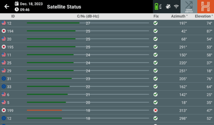
Satellite Status
When you click on the Satellite Status indicator, it will load the Satellite Status page. This page shows the satellites your HX-2+ is connected to and the strength at which they are connected.
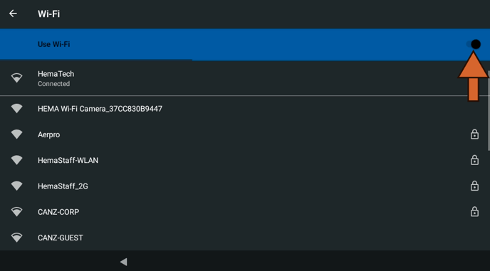
WiFi Indicator
If you click on the WiFi indicator, it will open the WiFi connections page.
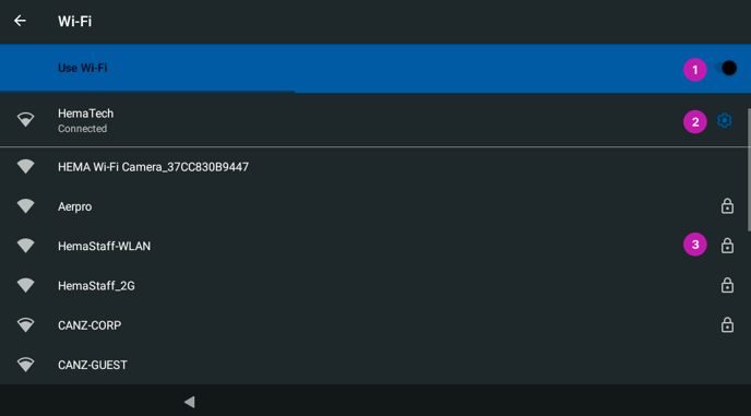
On this page, you can turn the WiFi On or Off by using the toggle switch on the right side [1]. You can also view the network you are currently connected to [2] or connect to a different network [3].
My Location
If you click on the My Location icon, it will lead you to the My Location page. This page lets you view your GPS coordinates in different formats, such as Elevation, Sunrise and Sunset times, and What3Words location.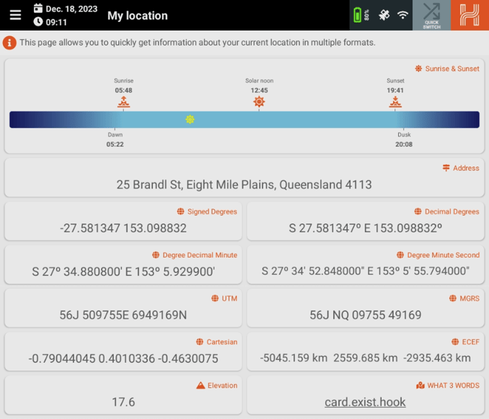
What3words is a geocoding system that allows you to communicate your location with a resolution of three meters. This system encodes geographic coordinates into three dictionary words, which are permanently fixed. For more information, please visit https://what3words.com/.
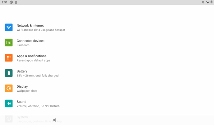
System Settings
When you click on the System Settings icon it will load the System Settings page.
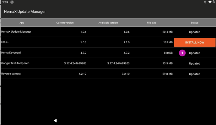
Software Updates
When you click on the Software Updates icon, the Software Updates page will load. This page checks and displays any system updates that are available for you HX-2+. If any of the items have Install to the right of them please click on Install to install the update. Once the update has been completed each item will say Updated [1].
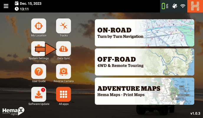
Data synchronisation, or data-syncing, is a crucial feature of your HX-2+. It allows you to:
- Save and secure your tracks, trips, waypoints, and points of interest on the Hema Maps Cloud. Access various tools to edit and customise your saved data.
- Explore other users' shared trips and tracks and Hema Map's featured destinations to enhance your next adventure.
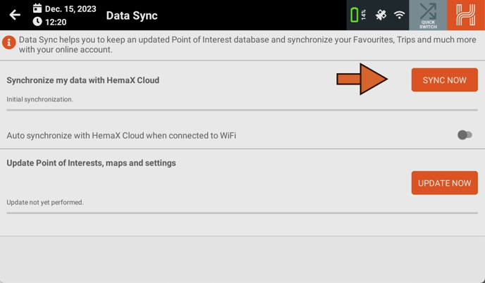
To access the Data-Sync Menu, tap the "Data Sync" button from the home screen, shown by the Cloud with two parallel arrows.
Once on the menu, you'll see two sections: "Synchronise my data with Hema Maps Cloud" and "Update Points of Interests, Maps and Settings".
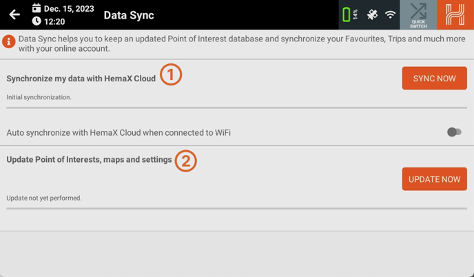
Let's start with "Synchronise my data with HemaX Cloud". This step will upload all the data stored on the HX-2+ to your account, and download anything created or edited on Cloud to the device.
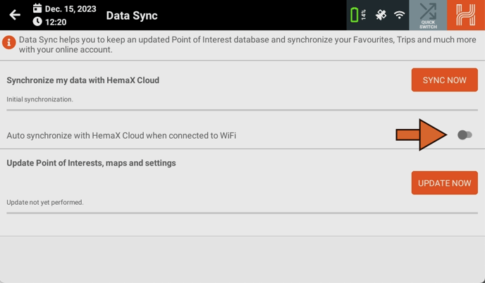
If you want the HX-2+ to automatically perform a data-sync whenever it detects a saved WiFi connection, turn on "Auto synchronize with HemaX Cloud when connected to WiFi".
We recommend doing this if you have enough WiFi data, as it helps take the burden off manually synchronising, lowering the risk of losing your saved items.
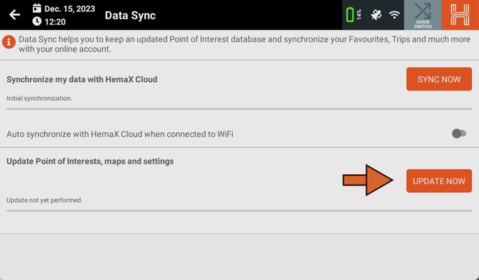
Updating the HX-2+'s Database
The second section, "Update Points of Interests, Maps and Settings", updates your device with the latest Points and interests, available add-ons, and settings. Begin by tapping "Update Now".
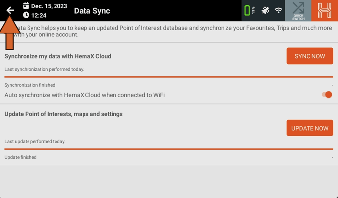
As with the first section, you can follow the progress of the sync with the:
- Progress bar
- Percentage counter
- Step number / descriptions.
Once your syncs have completed, return to the homepage.
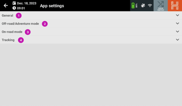
App Settings
When you click on the App Settings icon, it will take you to the App Settings page. This page displays the options for the main modes of the HX-2+. It is divided into four sections:
- General
- Off-road / Adventure mode
- On-road mode
- Tracking
General
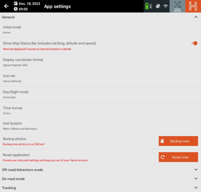
In the general settings you will find:
- Initial mode - this can be set to Home, On-road, Off-road or Adventure mode.
- Show Map Status Bar -Turns off or on the lower status bar on the map modes
- Display Coordinate Format - Choose the format to display coordinates at, Choices are SD, DD, DDM, DMS, UTM, MGRS, Cartesian or ECEF.
- Icon Set - Lets you choose the POI icons set, either Hema (default) or Hema Maps.
- Day/Night Mode - changes the theme of the on road map to be either night , day or automatic.
- Time Format - Can be 12 hr or 24 hr format.
- Unit System - changes the units used in the system, can be Metric, Imperial and US Imperial
- Backup Photos - clicking backup now will copy all photos and videos on the device to an installed SD card.
- Reset Application - This will erase all user data and settings and sign out of your Hema Maps account.
Off-road / Adventure mode
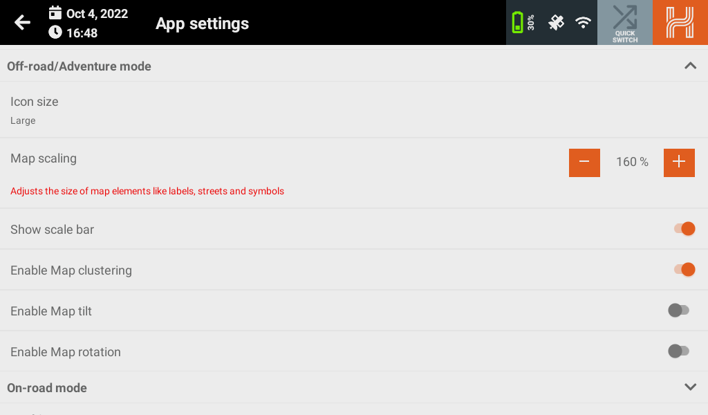
In the Off-road / Adventure mode settings you will find:
- Icon Size - You can choose between Small, Medium and Large (default)
- Map Scaling - Lets you adjust the size of the map elements.
- Show the scale bar - Lets you toggle the scale bar On/Off. On state shown.
- Enable Map Clustering - Lets you toggle the POI clustering On/Off. On State shown.
- Enable Map Tilt - allows a user to change their map viewpoint from an overhead look-down to a head on view. Off state shown.
- Enable Map Rotation - Lets you rotate the map through 360 degrees to enable the view you would like. Off state shown.
On-Road
In the On-road settings you will find:
Turn by turn options
- Route Type- Can be set to Balanced, Fastest and Shortest.
- Extrapolation - Predicts your location based on the road and your speed to combat lagging.
- Guidance Language - Alters the language and accent of the guidance voice.
- Voice - Alters the pitch and tone of the guidance voice.
- Realistic View - Lets you toggle Realistic View On / Off. On state shown.
- Camera Mode - Alters how the camera behaves whilst navigating.
- Tilt Angle - Reveals if 'Fixed camera' or Speed based camera' is active. Lets you set the angle of title for the map.
- Camera Distance - Reveals if 'Fixed camera' is active. Alters how far away the camera is from your location marker.
- Zoom Factor - Reveals if 'Speed based camera' is active. Alters how far away the camera zooms out when navigating at speed.
Routing Toggles

- Car shuttle train - Lets you toggle dirt roads On / Off.
- Control-access highway - This lets you toggle Control-access highways On / Off.
- Dirt roads - This lets you toggle dirt roads On / Off.
- Ferries - This lets you toggle ferries On / Off.
- Seasonal Closures - This lets you toggle roads with seasonal closures On / Off.
- Toll Roads - This lets you toggle toll roads On / Off.
- Tunnels - This lets you toggle tunnels On / Off.
- U-Turns - This lets you toggle U-turns On / Off.
Road Warnings
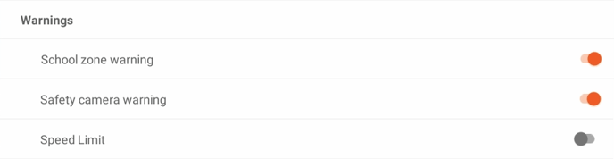
- School zone warning - Alerts you if a school zone is detected on your current road.
- Safety camera warning - Alerts you if a safety camera is detected on your current road.
- Speed limit - Alerts you if you exceed the speed limit for your current road. The alert will only be toggled once per road.
Speed limit options
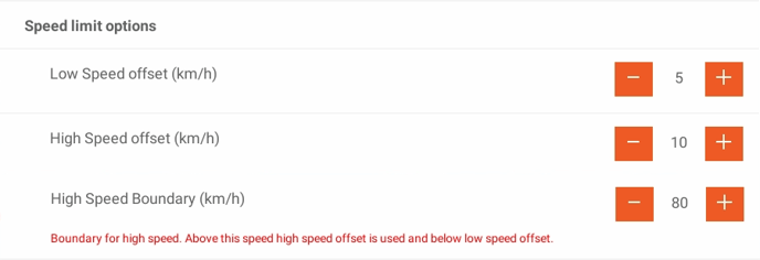
- Low-Speed Offset (km/h) - Receive a warning for travelling X km/h under the speed limit. For example, if you set the value at 10 km/h, you will be alerted if you drive 70 km/h on an 80 km/h road.
- High-Speed Offset (km/h) - Receive a warning for travelling X kms/h over the speed limit. For example, if you set the value at 10 km/h, you will be alerted if you drive at 90 km/h on an 80 km/h road.
- High-Speed Boundary (km/h) - Controls at which km/h the low-speed and high-speed boundaries are activated.
Map Styling
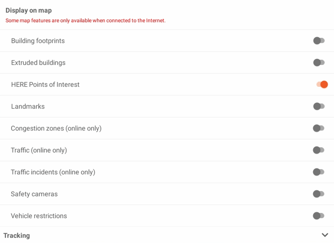
- Building footprints - Displays a 2D outline of buildings' footprints.
- Extruded buildings - Displays a 3D view of buildings' footprints.
- HERE Points of Interest - Displays Point of Interest icons from HERE's database. You cannot interact with these points of interest.
- Landmarks -
- Congestion zones (online only) -
- Traffic (online only) -
- Traffic incidents (online only) - Displays reported traffic incidents.
- Safety Cameras - Displays an icon on the map for reported safety camera.
- Vehicle Restrictions - Displays an icon with maximum vehicle heights. Please note that this does not affect routing.
- Show Traffic - toggles traffic information On / Off. On state shown. (must be connected to a data network to receive traffic information)
Tracking
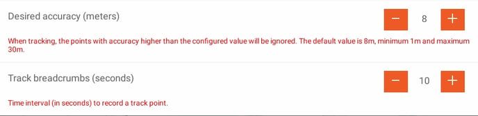
In the Tracking settings, you will find the following:
- Desired accuracy - This lets you set the value at which the recorded points will be ignored. Please note that increasing the value may improve the tracking.
- Track Breadcrumbs - This lets you set how many seconds between each point dropped when recording.
On-Road
Screen Layout
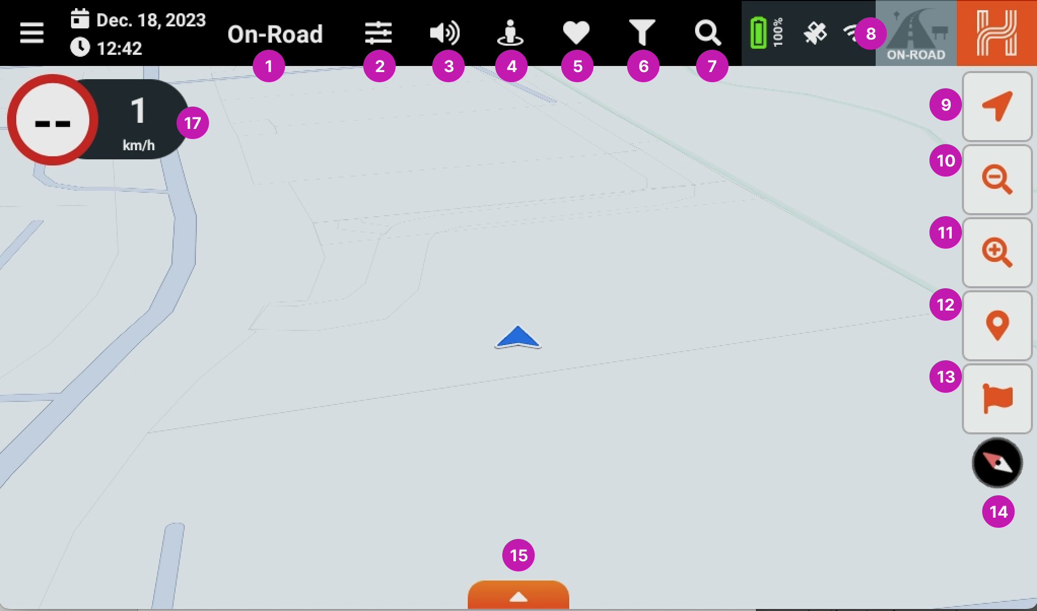
- On-Road - This lets you know what mode the HX-2+ is in.
- Application Settings - You can access the HX-2+ settings here.
- On-Road Volume - Toggle the volume on and off.
- Near me - Show Points of Interest (POI’s) close to you.
- Favourites - Shows your favourite POI’s.
- Map Filters - Lets you customise the POI’s you want to display on the map.
- Search - Lets you search the On-road Program.
- Quick Mode Select - Easily switch between the navigation modes on the HX-2+.
- Location button - Lets you center the map to your current location.
- Zoom out - Lets you zoom the map out.
- Zoom in - Lets you zoom the map in.
- Points of interest Toggle button - Toggles the POI’s on/off - shown in enabled state.
- Waypoint Toggle button - Toggles the Waypoints on/off - shown in enabled state.
- Compass button - Displays your current bearing, with north being the red needle. Pressing it orientates the map to north-up.
- Hidden statistics bar - Shows or hides the hidden statistics bar - currently hidden.
- Speed widget - Displays your moving speed and the speed limit for your current road.
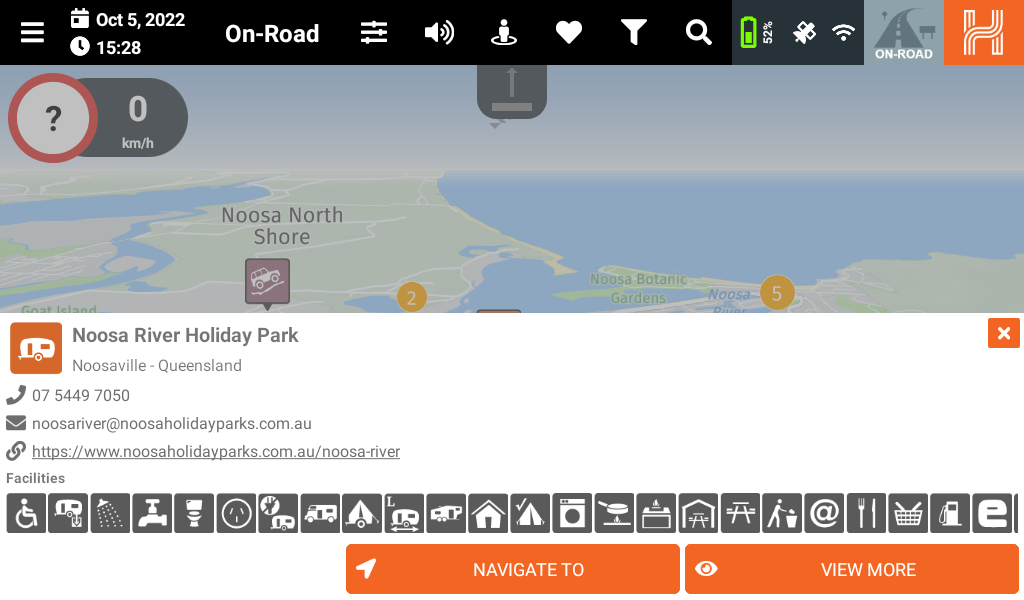
Near me
The Near Me function shows the POIs near you and the distance to them.
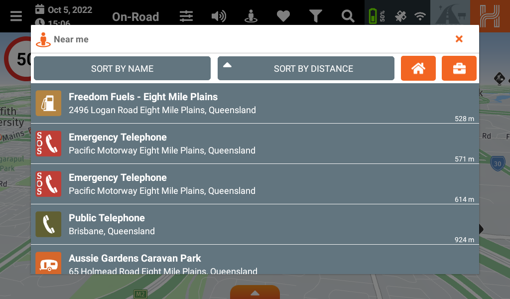
You can select their displayed order by clicking Sort By Name or Sort By Distance.
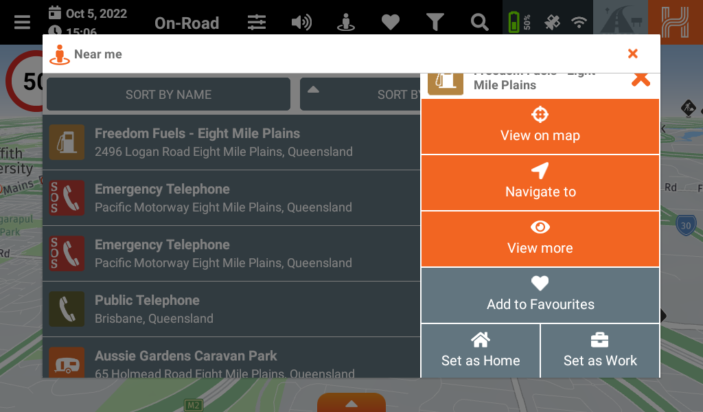
When you select a POI, you will be given more options.
- View on Map will show the POI on the main map.
- Navigate to will guide you to the POI.
- View More will show you more detailed information about the POI selected.
- Add to Favorites will save the POI as a favourite
- Set as Home will save the POI as your Home address
- Set as Work will save the POI as your Work address
Navigate to
If you click on Navigate to the HX-2+ will calculate the route to the POI. You will be given the choice of routes [7] and then you can either Cancel [8] or Start [9].
The route will be displayed on the map [10].
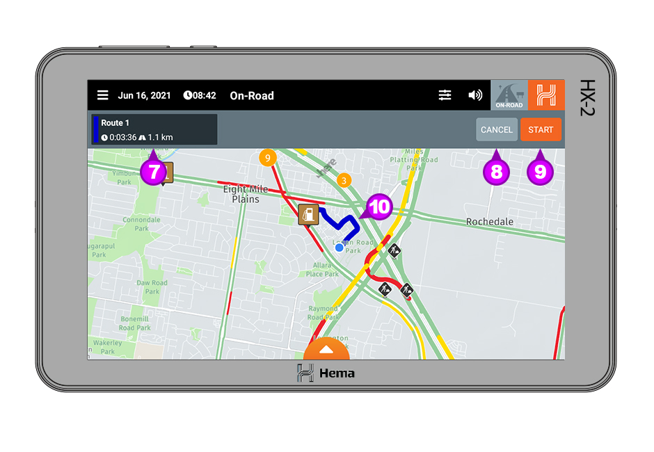

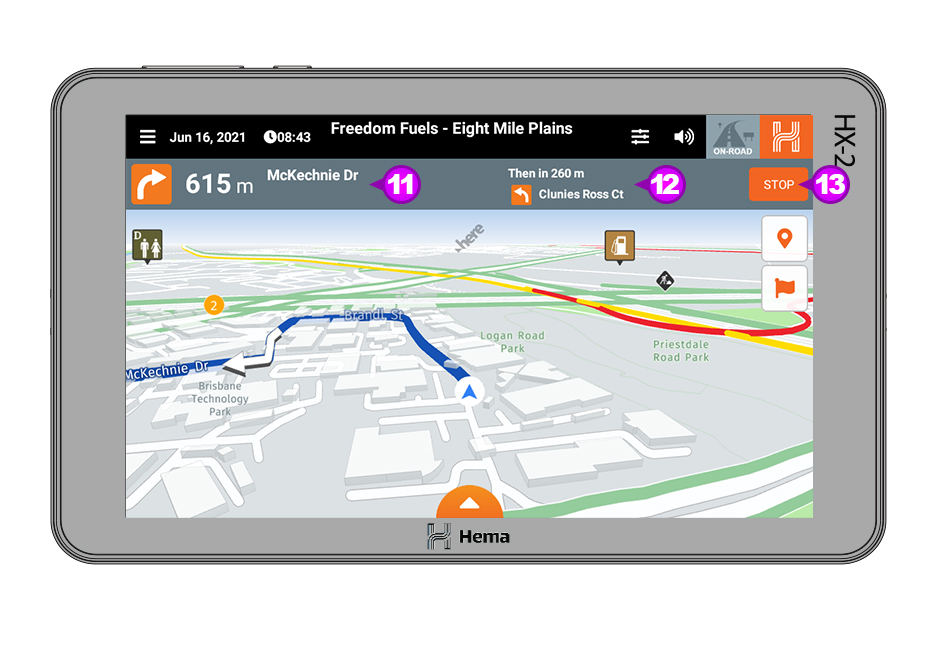
When you click Start then the HX-2+ will start to guide you on your route.
You will see the Direction and distance to the next turn as well as the street name [11] and also the distance and direction for the next turn [12]. If you wish to cancel the route click on Stop [13].
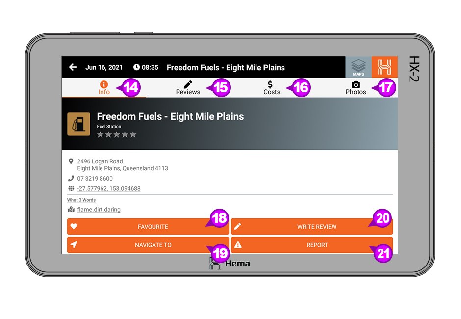
View More
If you click on View More than you will be provided with more detailed information for the selected POI.
You can choose between the four main headings;
- Info [14]
- Reviews [15]
- Costs [16]
- Photos [17]
You can also;
- Add the POI to your Favourites [18]
Navigate to the POI [19] - Write a review of the POI [20]
- Report the POI [21]
Favourites
In this section you will see any POI’s you have favourited.
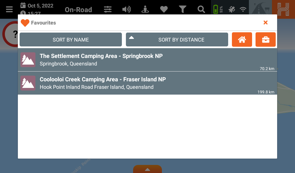
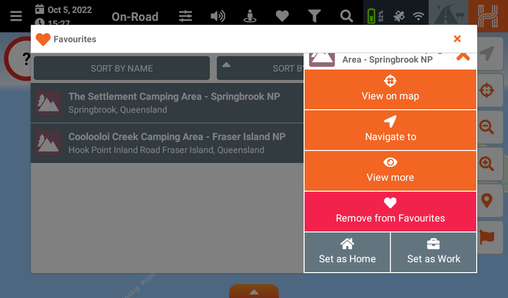
When you select a POI from the list you get the following options.
- View on Map
- Navigate to
- View More
- Remove from Favorites
- Set as Home
- Set As Work
Add and remove Favorites
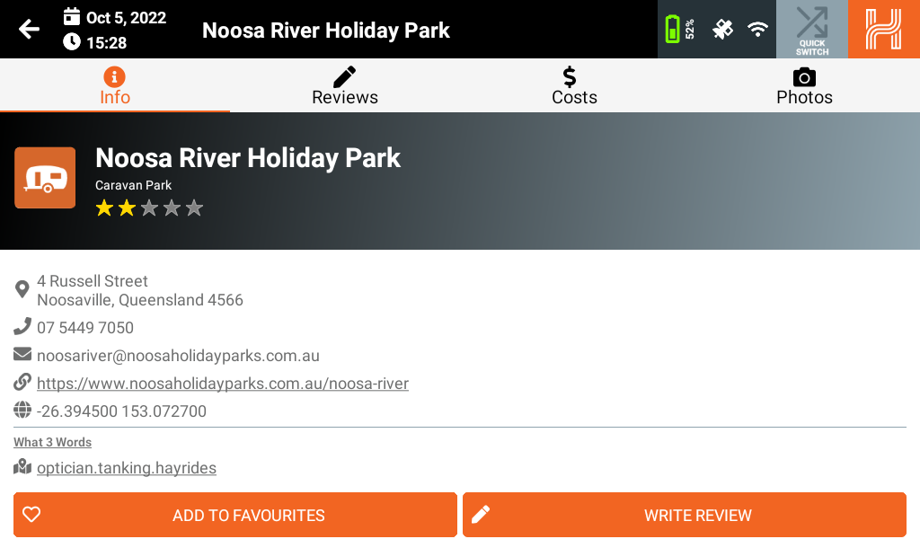
To add a POI as a favorite, select the POI and from the banner that appears from the bottom click on View More.
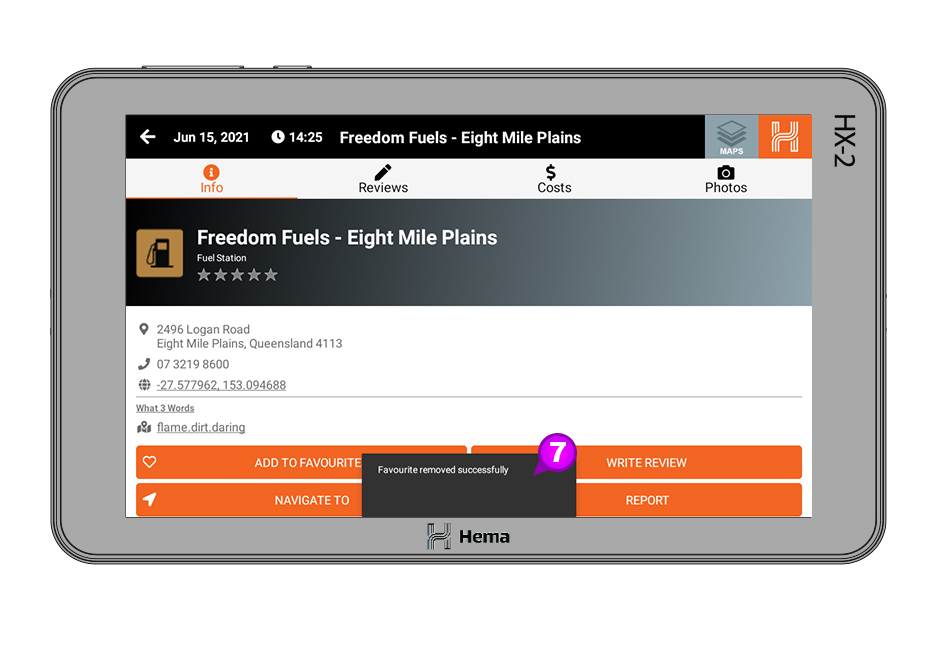
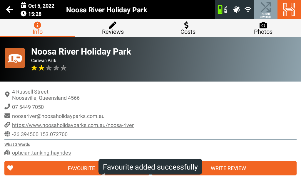
In the POI information screen click Add to Favourites.
You will then get the notification on the bottom of the screen Favourite added successfully.
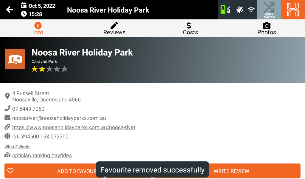
To remove the selected POI from your Favourites just repeat the above process and click on Favourites and you will get the notification Favourite removed successfully.
Home and work?
Map Filters
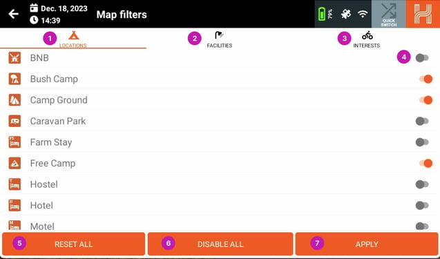
The Map Filters function lets you filter what POI’s are shown on the map.
There are three categories of Filters;
- Locations
- Facilities
- Interests
For each of the items you can set the state on or off by clicking on the toggle on the right hand side [4], This is shown in the on state.
Please note: Any options you choose in the Facilities and Interests will override the selections made in the Filters section.
Alternatively you can use the functions at the bottom;
- 5 Reset All - reset the filters back to default
- 6 Disable All - sets all the filters to off
- 7 Apply - apply the selections you have made
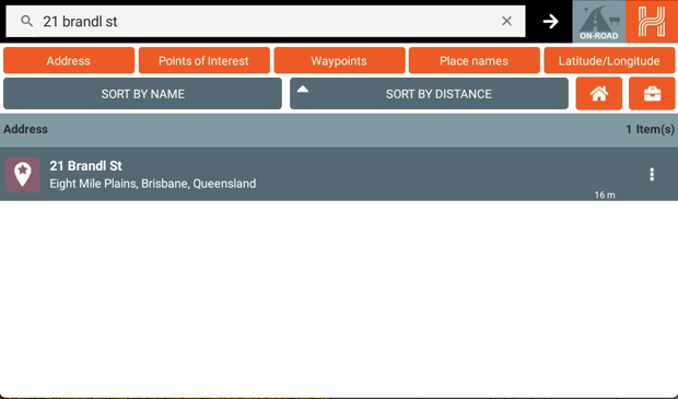
Search
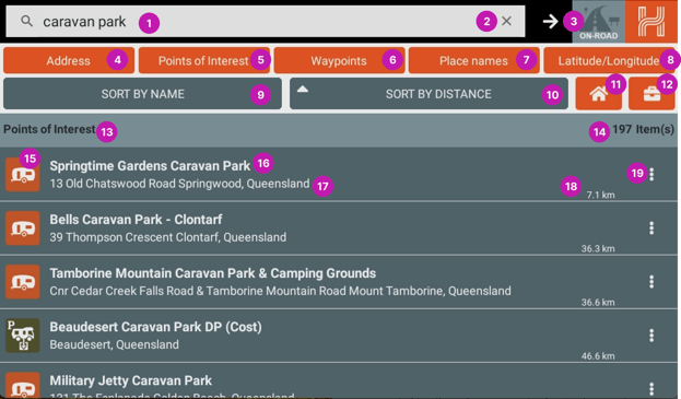
- Clicking on the search icon will bring up the maps.
- Pressing "X" clears the search term and results.
- Pressing the arrow searches anything written in the search bar.
- Toggles On/Off addresses in search results
- Toggles On/Off Points of Interest in search results
- Toggles On/Off Waypoints in search results
- Toggles On/Off Place names in search results
- Toggles On/Off Latitude / Longitude in search results
- Sorts search result by alphabetical order
- Sorts search results by distance from your position
- Automatically begins routing to the address you've set as 'home'
- Automatically begins routing to the address you've set as 'work'
- Subheading for search results' type.
- Number or search results for the search results' type.
- Icon for search result type.
- Name of search result's location/address/business name.
- Address of the search result.
- The distance between your location and the search results' location.
- Brings up the side menu for the search result.
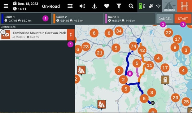
Once you have selected your destination your HX-2+ will start to calculate the route.
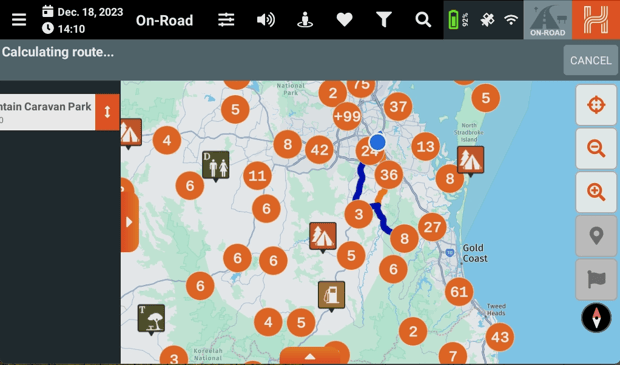
When your HX-2+ has calculated the route it will display a series of alternatives [1], and then you can either Cancel [2] or Start [3] the route. You can also add additional locations as stops and reorder them by holding and dragging on the opposite-facing arrows
Home and Work Locations
Setting a home and work location is the same process for each.
Tap on the search icon at the top of on road mode, and tap in the search window.
Type in your address until it displays in the search options.
Tap on the 3 dot icon on the right side of your address to open more options
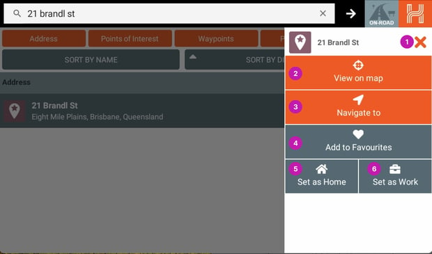
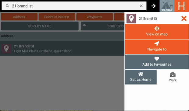
Tap on the Set as Work Button
When successful the set as work button will highlight white
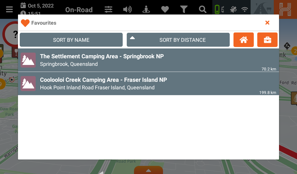
Now when you wish to quickly travel to your work or home address, you can do so by selecting the favorites icon from onroad mode.
And then tapping the work/home icon in the top right corner.
The hx2 will create a route to your work/home locations.
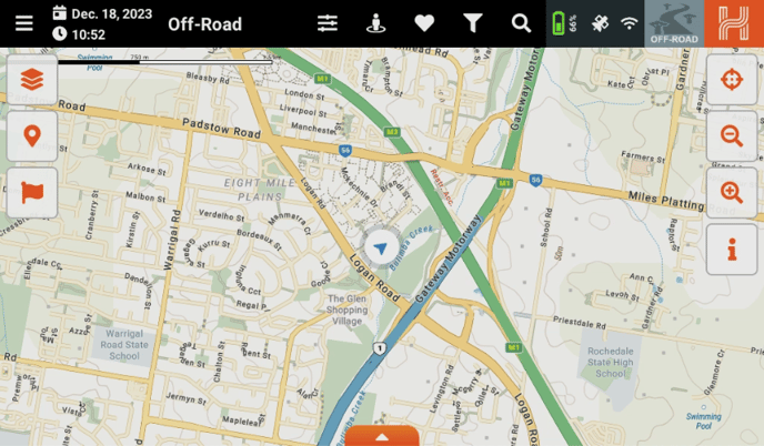
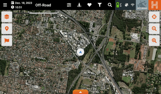
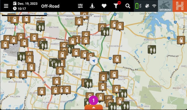
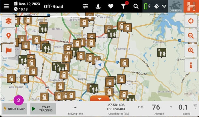
Off-Road
Screen Layout
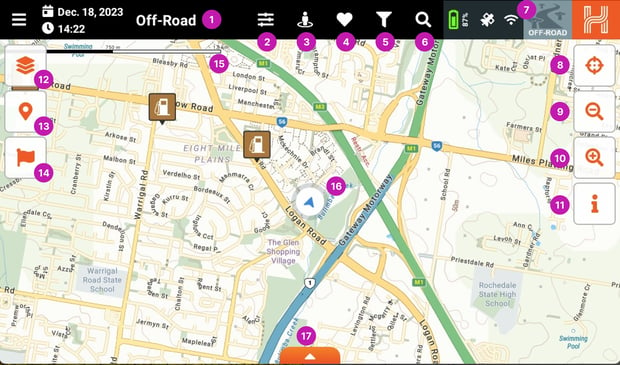
- Off-Road - This lets you know what mode the HX-2+ is in.
- Application Settings - You can access the HX-2+ settings here.
- Near me - Show Points of Interest (POI’s) close to you.
- Favourites - Shows your favourite POI’s.
- Map Filters - Lets you customise the POI’s you want to display on the map.
- Search - Lets you search the On-road Program.
- Quick Mode Select - Easily switch between the navigation modes on the HX-2+.
- Location button - Lets you center the map to your current location.
- Zoom out - Lets you zoom the map out.
- Zoom in - Lets you zoom the map in.
- Map Legend - Displays a Legend of the map.
- Map Style selection - Displays a menu to select the map's style.
- Points of interest Toggle button - Toggles the POI’s on/off - shown in enabled state.
- Waypoint Toggle button - Toggles the Waypoints on/off - shown in enabled state.
- Map Scale - Displays the scale of the map relative to your zoom level.
- Location cursor - Displays your location on the map.
- Hidden statistics bar - Shows or hides the hidden statistics bar - currently hidden.
Raster Maps vs Vector Maps
The HX-2+ uses both Raster and Vector maps. Here is a brief explanation of the two types of maps.
|
Raster Map |
Vector Map |
|
Raster or bitmap images are made of composed square pixels. |
Vector images are made of points that form lines and shapes dictated by mathematical formulas. |
|
The disadvantage over vector is that raster images are relying on their set image resolution. When zooming into a raster image the image gets blurry and pixelated. |
The advantage over raster is that graphics using a vector solution are always displayed crisp and sharp on any device's resolution. When zooming into a vector graphic the image is always nice and sharp. |
|
Depending on the image resolution raster images are bigger and take up more disk space. |
Vector graphics are smaller in file size and take up less disk space. |
|
Sample Raster image |
Sample Vector image |
|
|
|
|
The raster maps in the 4x4 Explorer app are images of selected Hema print products in a digital form. The POI and facilities are static and in the map file embedded. |
The vector maps in 4x4 Explorer are highly interactive maps. While zooming and panning the map content changes depending on the zoom level. The POI and facilities are interactive and 'floating' on the map - they can be rated and updated within the app. |


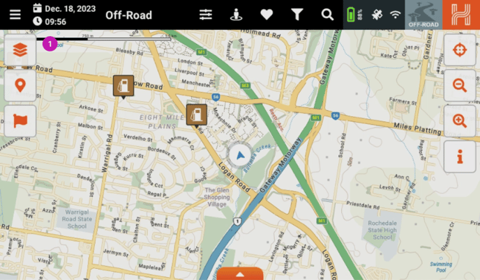
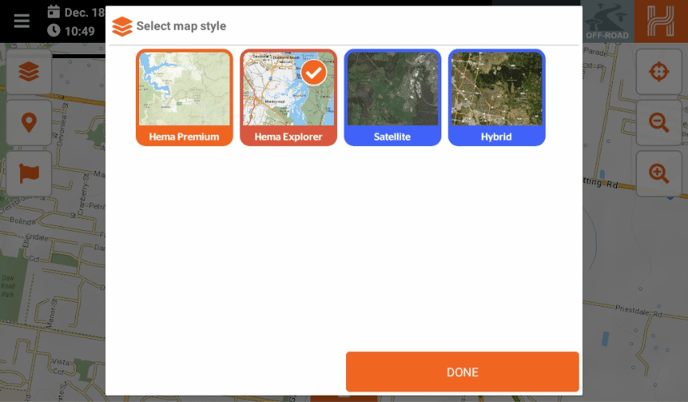
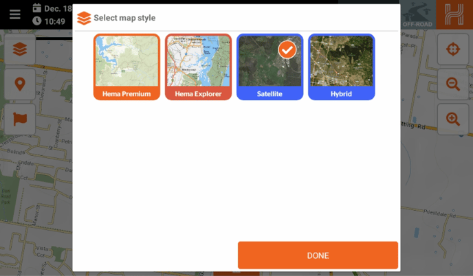
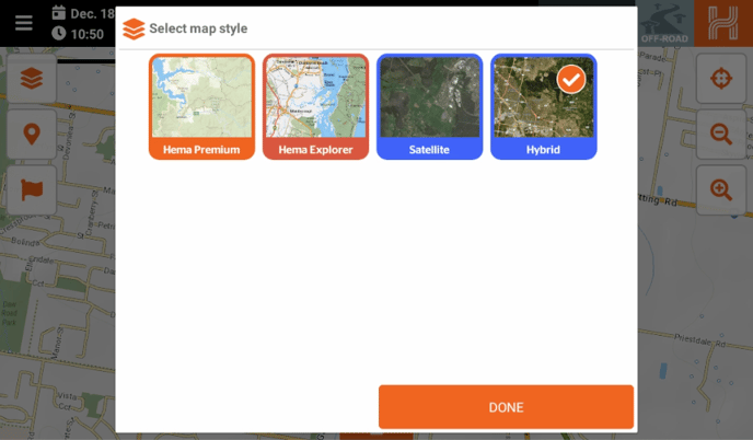
Map Styles
The mapping content that is displayed on the main screen is set using the Map Styles menu. This is accessed from the Map Styles [1] button on the left hand side of the main map.
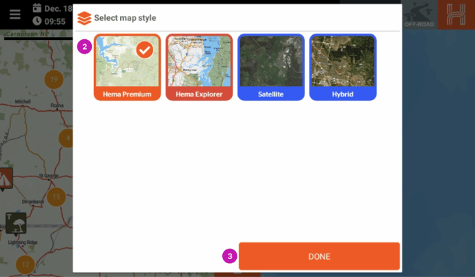
To apply the Map Style of your choice click on the map style so it has a tick in the box [2] the Done [3] button.
There are four different styles that can be chosen:
- Hema Premium
- Hema Explorer
- Satellite
- Hybrid Satellite
1. Hema Premium
These are our premium set of Vector maps.
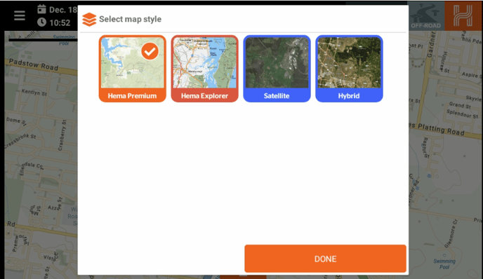
2. Hema Explorer
This is the Raster, multilayered Hema Explorer Map from the HX-1, Hema Atlases and Maps.
3. Satellite
This is a Satellite map overlay. This is only available with a data connection.
4. Hybrid Satellite
This is a combination of the Hema Points of interest, road data and the satellite data. This is only available with a data connection.
Map Updates
It is important to note that your device comes with preloaded maps. Still, newer maps may be available during your setup.
To ensure you are navigating with the most up-to-date maps, you will receive popups whenever a new map is released. This will keep you informed and allow you to easily install the latest maps for your device.
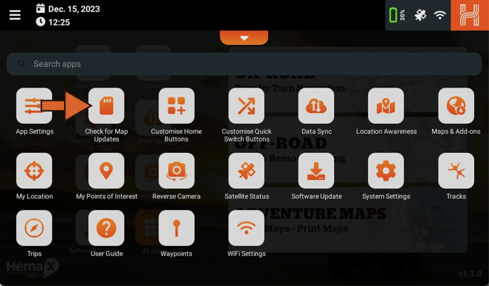
To install new maps on your device, follow these steps:
- From the home screen, open "All Apps".
- Find and open "Check for Map Updates" in the application drawer's top left corner.
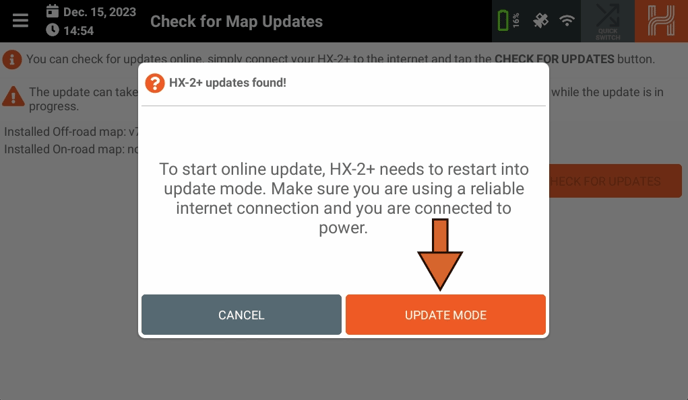
If there are any map updates available, a popup will appear. Tap "Update Mode" to start the installation process.
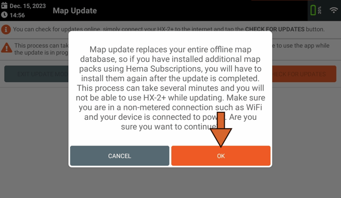
The HX-2+ will reboot into a new page, called "Map Update", with a popup appearing explaining that you will have to reinstall additional map packs is you have previously done so. Tap "OK".
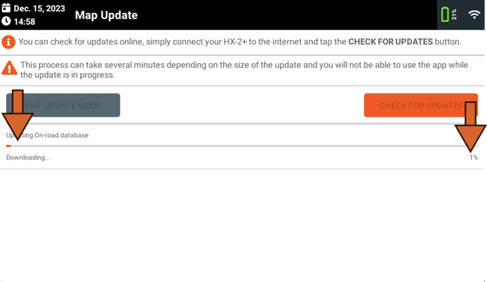
Your map updates will now begin. Map updates are divided into two sections: On-road and Offroad, with Offroad being first, followed by On-road.
As with the first section, you can follow the progress of the sync with the:
- Progress bar
- Percentage counter
- Step number / descriptions.
Always double check you have enough data available to complete the update, and ensure you a have a strong, stable connection.
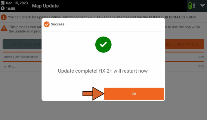
Once the downloads have completed, a popup will appear asking you to reboot. Tap "OK."
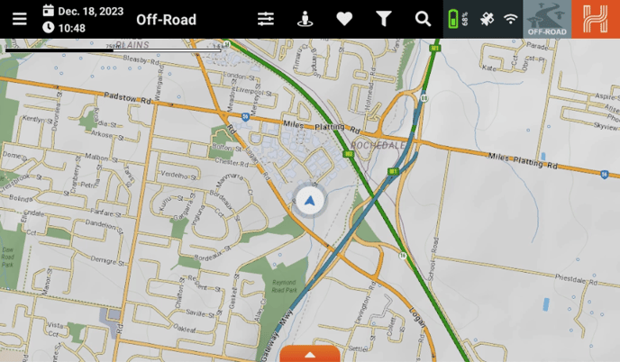
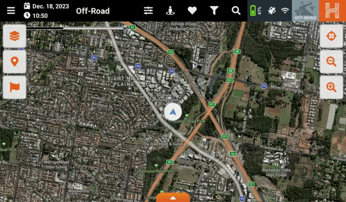
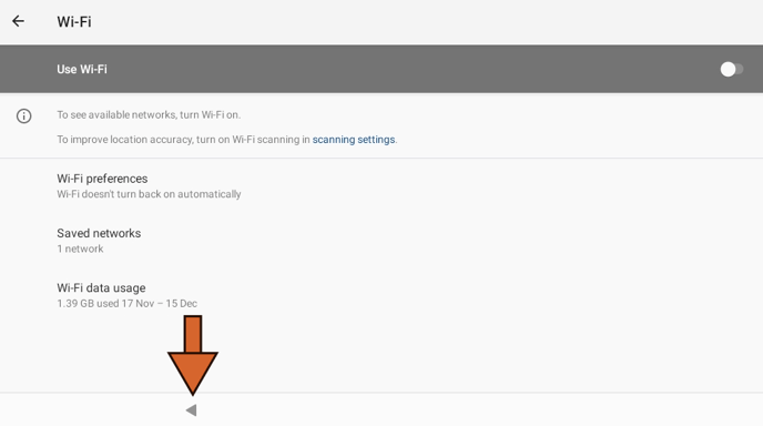
To ensure your maps have downloaded correctly, it is helpful to disconnect your device from Wi-Fi and check if the maps are loading properly. This allows you to verify that the maps have been successfully downloaded and are ready to use.
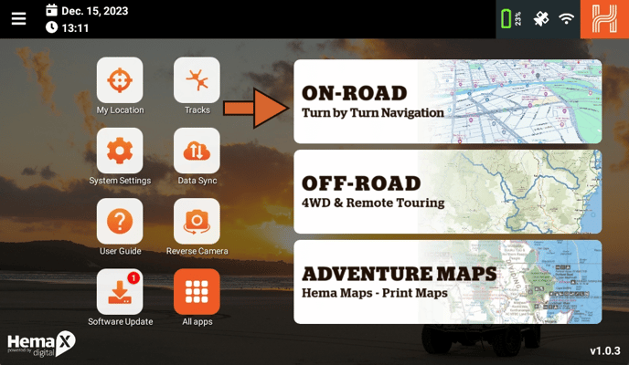
If your maps have been installed correctly, you will be able to view the entire map of Australia in full detail and create routes to any chosen destination.
.png?width=688&height=403&name=Image%20from%20Chat%20(1).png)
No Map update Available
If you open the check for map update page and receive the following message.
This is typically indicative that there are no map updates available and your current set of installed maps are the latest available from hema.
Please double check that your HX2 is connected to a WiFi network first as you will also receive this message if you are checking for updates with no current internet connection.
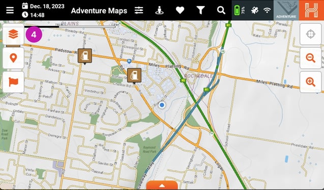
Adventure Maps
Screen Layout
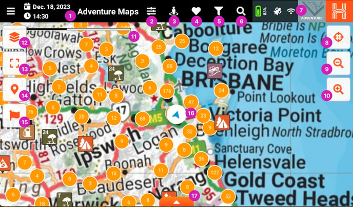
- Adventure Maps - This lets you know what mode the HX-2+ is in.
- Application Settings - You can access the HX-2+ settings here.
- Near me - Show Points of Interest (POI’s) close to you.
- Favourites - Shows your favourite POI’s.
- Map Filters - Lets you customise the POI’s you want to display on the map.
- Search - Lets you search the On-road Program.
- Quick Mode Select - Easily switch between the navigation modes on the HX-2+.
- Location button - Lets you center the map to your current location.
- Zoom out - Lets you zoom the map out.
- Zoom in - Lets you zoom the map in.
- Map Scale - Displays the scale of the map relative to your zoom level.
- Map Style selection - Displays a menu to select the map's style.
- Full map zoom - Zooms out to display the entire map.
- Points of interest Toggle button - Toggles the POI’s on/off - shown in enabled state.
- Waypoint Toggle button - Toggles the Waypoints on/off - shown in enabled state.
- Location cursor - Displays your location on the map.
- Hidden statistics bar - Shows or hides the hidden statistics bar - currently hidden.
How Do I Load Different Maps
The Adventure Maps mode lets you access the Hema Iconic Print Map series on your HX-2+.
By default the Adventure mode will load the state map relevant to your GPS position.
To choose which map is loaded, click on the Map Styles button on the left hand side of the main map.
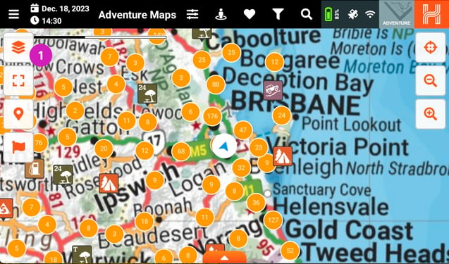
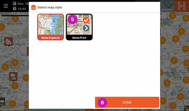
From the Map styles window you can choose two options;
- The Hema Explorer - 150K seamless Australia wide map
- The Hema Print Maps - Hema’s icon print maps.
You will now see the Hema Explorer map displayed on the screen.
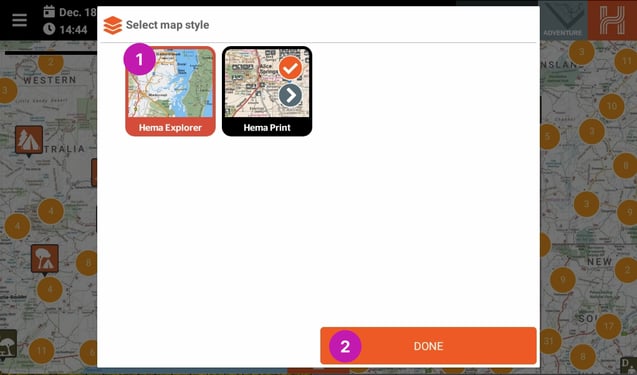
To load one of the Hema Print Maps, click on the Map Styles [4] icon.
Then from the Map styles window click on the Hema Print [5] icon so it has a tick in it. To select which of the Hema Print maps is loaded, click on the > [6] icon.
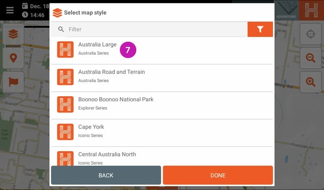
When you click on the > [6] icon a list of the Print maps will be displayed. Select the Print Map you would like to load [7].
Once you have selected the desired map you will see a tick [8] appear to the right of the title and then you can click Done [9] to load the map.
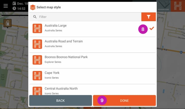
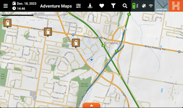
You will now see the selected map has loaded in the centre of the screen.
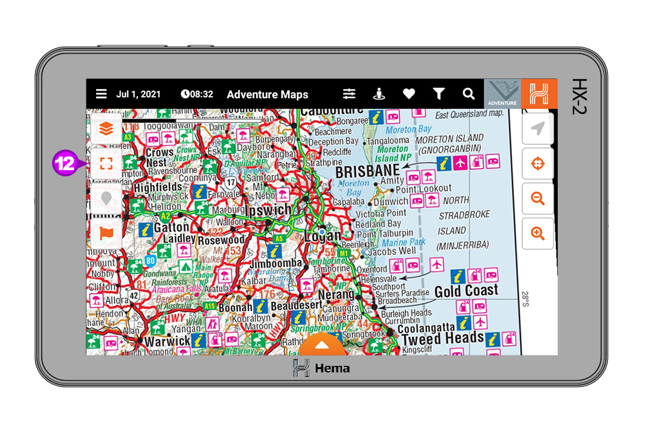
Zoom All
The Adventure maps mode has a unique zoom feature that lets you reset the zoom level on the map you are viewing. Please note this is only available on the Hema Print maps and not the Hema Explorer Map as it is a seamless map.
All you need to do is zoom in to the desired level either using the Zoom In [10] or Zoom out [11] buttons
and then click the Zoom All [12] button to rest the zoom level.
Trips
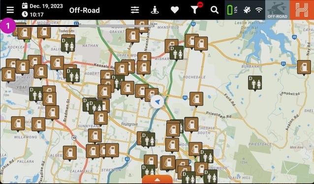
In this section we will look at the Trip planning engine in your HX-2+. You can access this by going into the Main Menu [1].
and then click on Trips [2].
Starting a New Trip
When the Trips page opens for the first time there will be no active trips. To create a new trip, click on Start New Trip [3].
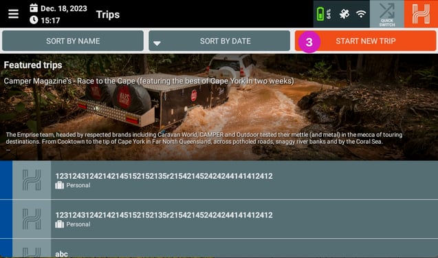
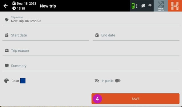
When you click on start new trip, the new trip page will load. You will need to give your new trip a name, select a start and finish date and also select a reason for the trip. Once you have completed this please click Save [4].
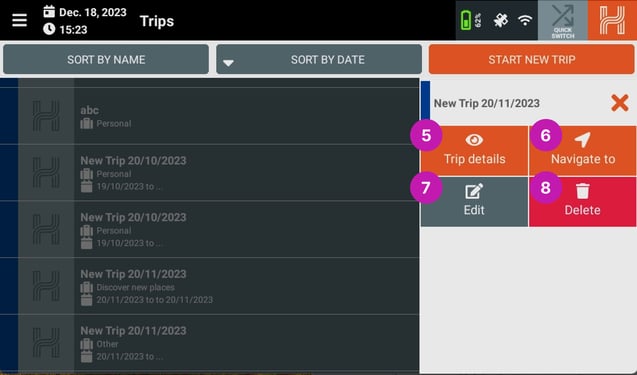
When you have saved your trip it will be displayed in the trip list. If you click on your trip in the trip list you will see three options drop down. They are;
5 Trip details - Shows the trip details
6 Navigate to - Creates a route to the location in On-road mode.
7 Edit - Edits the trip information
8 Delete - Deletes the trip
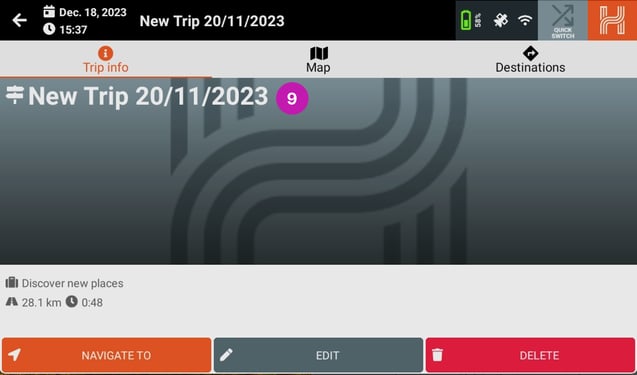
To start planning your trip click on Trip Details and then the trip information page will load.
At the top of the trip information page you will see the Trip Name [9].
Adding A Destination
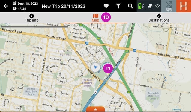
To start adding destinations to your trip, click on the Map [9] heading at the top of the page.
You will see your current position marked as the blue circle [10] on the map. We will use this as the first destination in our trip. To add this as the first destination simply click and hold down on the screen for 2 seconds about your current location.
You will then get a dialog box asking if you want to add new destination here? To add this destination click OK [12].
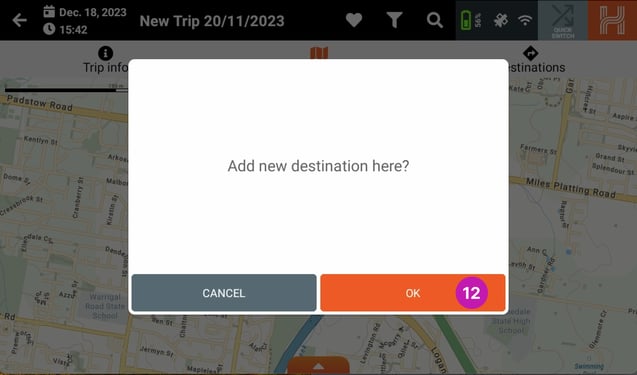
When you click OK you will be asked to add some details about the destination. You can edit the name of the destination, check its coordinates and add other information about the destination. When you are happy with the information, please click Save [13] to confirm and add your destination.

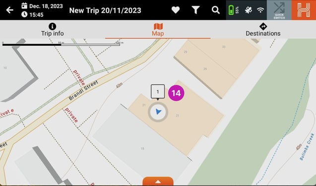
After you click save, you will be taken back to the Map and you will see a 1 icon [14] to indicate the destination has been added.
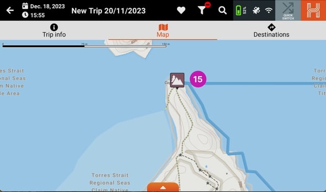
Adding More Destinations
Now it is time to add another destination to your trip. You can either add another custom destination or you can select an existing POI. For this example we will use an existing POI, the northernmost tip of Cape York [15].
When you click on the POI icon you will be given more detailed information about the POI and then three drop down options.
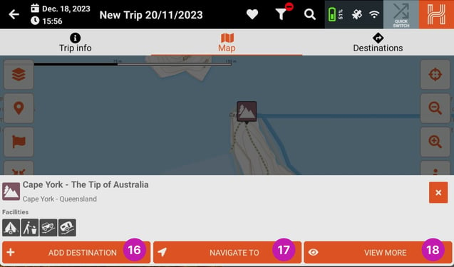
- 16 Add Destination
- 17 Navigate To
- 18 View More
If you click on Navigate To, your HX-2+ will open the On-road mode to give you turn by turn directions to that destination.
Clicking View more will bring up more detailed information about that POI. For this example we will click Add Destination.
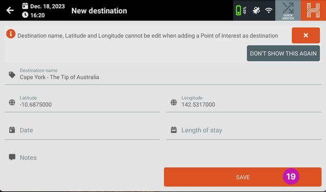
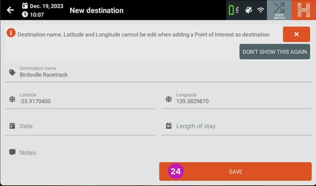
When you click on the Add Destination you will get the new destination page but you will see the title will already be filled in.
To add this destination please click Save [19].
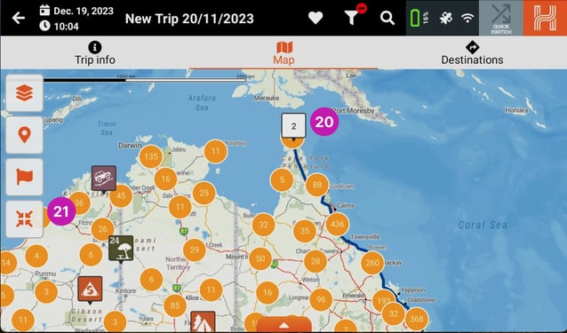
Once you have clicked save you will see the destination has been added with a 2 icon [19].
To see the entirety of your trip, click the Zoom to fit icon [20] and you will be shown the whole trip.
You can add multiple destinations to any trip. The only limitation is the trip length which cannot exceed 11,000 kms.
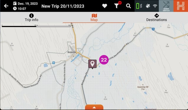
To add another destination we follow the same process. For this example we will choose the Birdsville Racetrack [21].
Once you select the destination, click Add Destination [23]
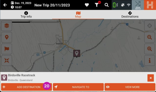
and then when you're happy with the destination information, click Save [23].
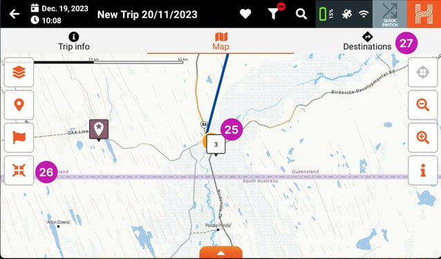
Once you have clicked save you will see the destination has been added with a 3 icon [25].
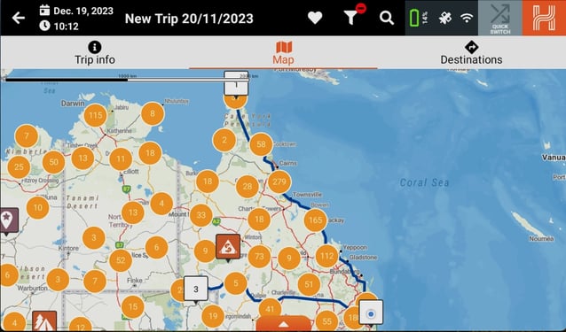
Click the Zoom to fit icon [27] and you will be shown the whole trip and you will see all three destinations.
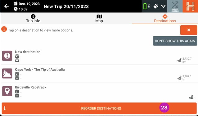
Reordering Your Destinations
If you like the destinations in a different order, you can select the Destinations [27] page. On the destinations page you will see the three destinations that have been added. At the bottom of the page you will see the Reorder Destinations [28] button.
You can now reorder the destinations in the trip by clicking the arrows on the right of the destination [29] and then dragging the destination to its desired spot in the list.
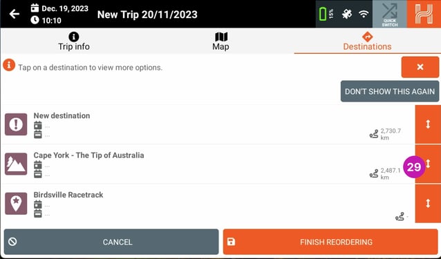
Once you have the destinations in the desired order, click on the Finish Reordering [30] button
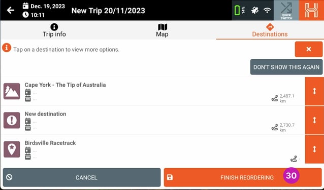
You will then see that the destination list has been reordered.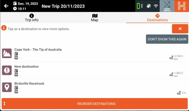
Return to the map and click the Zoom to fit icon and you will see all three destinations in the new order.
Removing Destinations
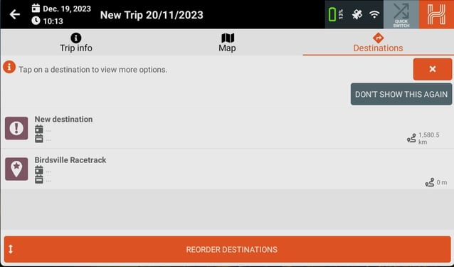
You can also edit or remove destinations from the Destinations page.When you select one of the destinations you will be given five options for that destination:
- 32 Show on Map
- 33 Navigate To
- 34 More Information
- 35 Edit
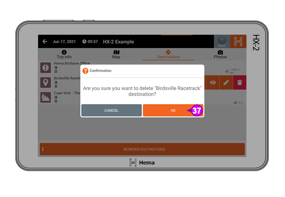
- 36 Delete
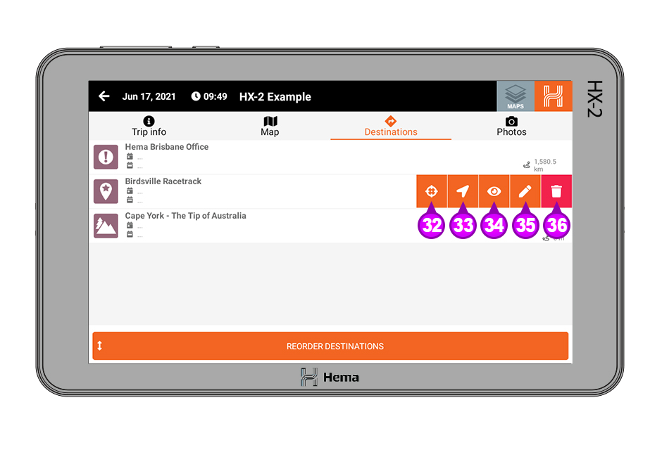
To remove the destination from the List click on the Delete [36] button and you will be prompted to make sure you want to delete the destination. If you wish to proceed click OK [37].
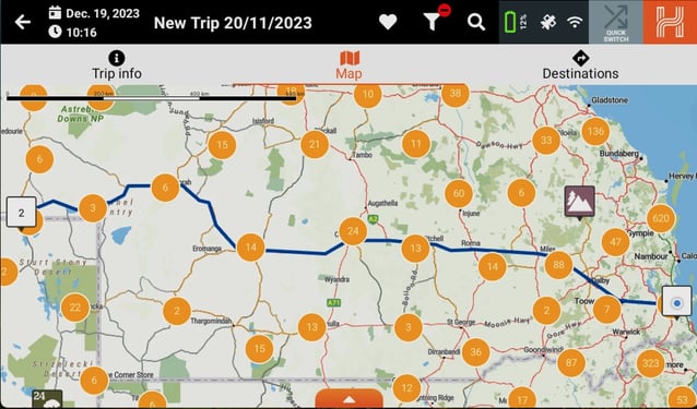
Once you click OK you will see that the destination has been removed from the destination list.
Return to the map and click the Zoom to fit icon and you will also see that the destination has been removed and only two remain.
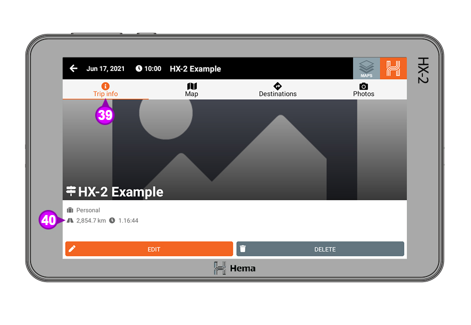
You can also see the total distance for the trip by clicking on the Trip Info [39] page and then looking under the trip name for the trip statistics [40].
Tracks
The tracks section of the HX-2+ is primarily for recording the tracks you are travelling on.
Recording a Track
There are multiple ways you can record a track on the Hema HX-2+.
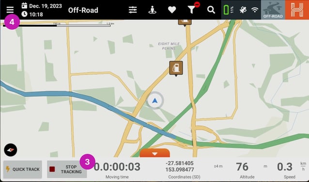
Quick Record from Hidden Statistic Bar
The quickest way to start a tracking record is to open the Hidden Statistic Bar [1] in either On-road, Off-road or Adventure mode
and then click on the Quick Record icon [2].
This will start a new track recording. You will see that the Start Tracking button changes to Stop Tracking and if you want to stop recording, click the Stop Tracking [3] button. When you click Stop Tracking the track will then be saved.
You can view your saved tracks by clicking on the Main Menu [4] icon,
and then clicking on Tracks [5] from the drop down menu.
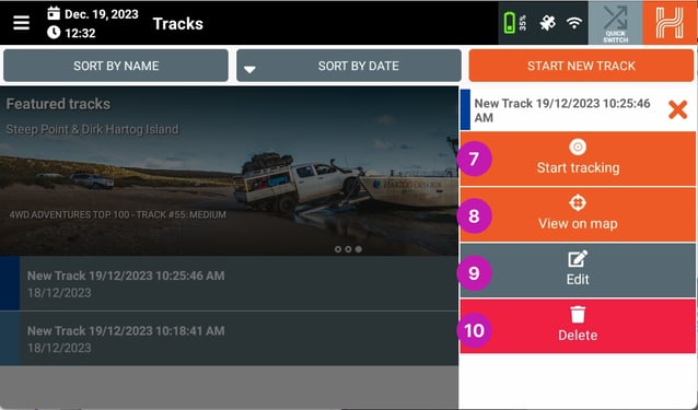
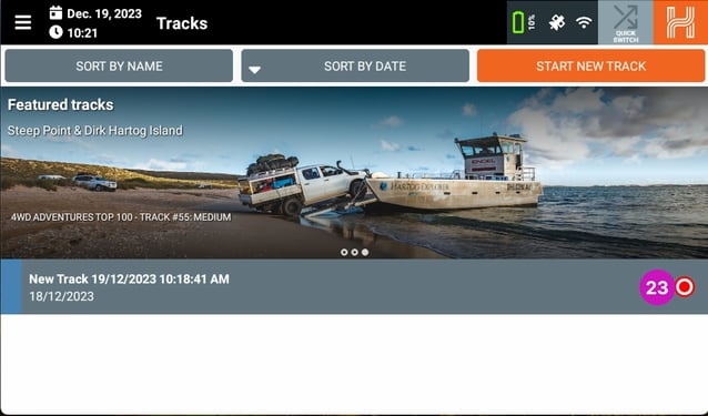
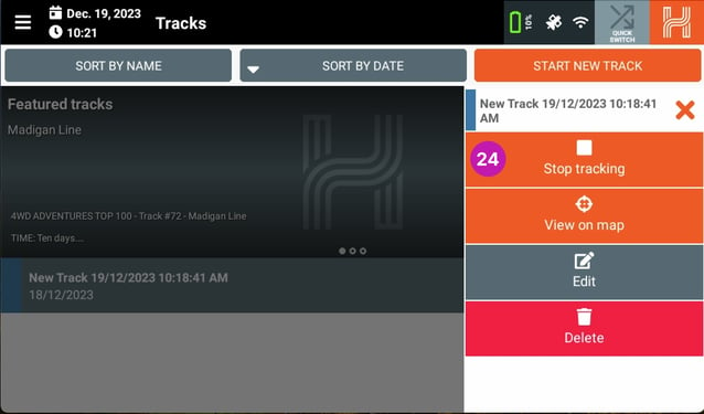
When the tracks page loads you will see the tracks you have recorded [6]. When you select a track you will see the following options;
- 7 Start tracking - you can resume a previously recorded track with this option. Please note that if you are at a different location to when you stopped recording, you will get a straight line between the two points.
- 8 View on map - this lets you see the track you record on the main map.
- 9 Edit - this lets you edit the track information.
- 10 Delete - this lets you delete the track.
Start Tracking from Hidden Statistic Bar
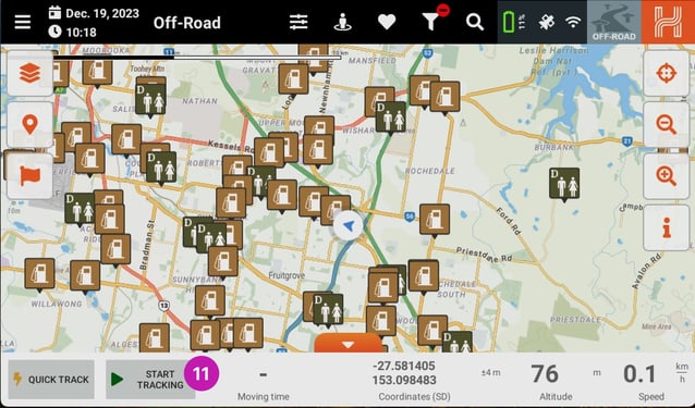
You can also use the Start Tracking [11] button in the Hidden Statistic Bar.
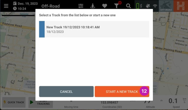
Once you have clicked on the Start Tracking button you will be asked to select a track from the list or start a new track.
If you would like to start a new track click on the Start A New track [12] button. You can also select a previous track and continue that recording.
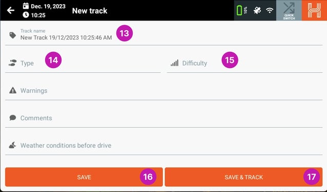
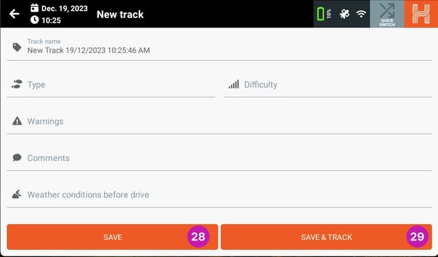
If you choose to start a new track then you will be asked to enter some information for the new track. Once you have imputed the required information, Track Name [13], Track Type [14] and Track Difficulty [15], you can either Save the track or Save & track. Please note you will need to input the Type and Difficulty in order to save and save & track.
If you click the Save [16] button in the bottom left then your track location will be saved and you can record at a later time using the Start Tracking button in the Tracks section.
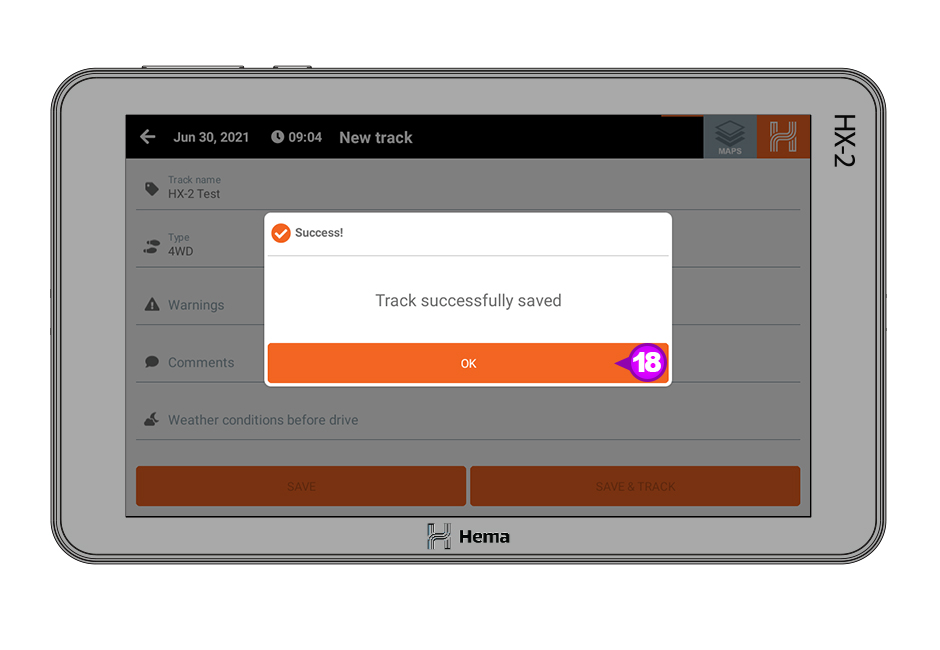
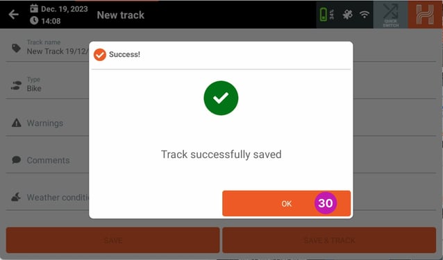
If you click the Save & track [17] button in the bottom right hand corner you will be notified that the track has been saved.
When you get the notification that your track has been saved, click OK [18] and you will be returned to the main map.
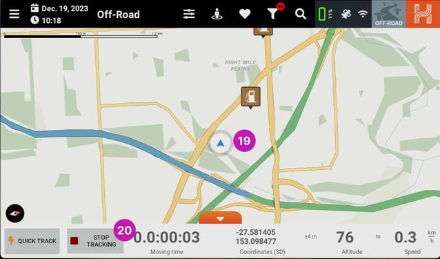
When you are returned to the Map you will see that the location marker has changed [19] and the Start Tracking button has changed to Stop Tracking [20]. To finish the recording click on the Stop Tracking [20] button.
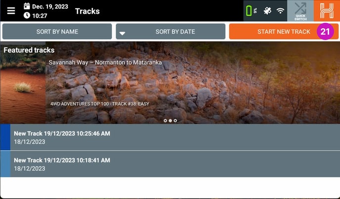
Starting a Track from the Tracks page
You can also create a new track from the Tracks page. To start a new Track either click on the Start New Track [21] and then fill in the required information as per the Start Tracking section.
When you are ready to record click the Save or Save & track.
Resuming a Track
If you would like to resume a previously recorded Track, you can do that from the Track page.
Click on the track you wish to resume and then click Start tracking [22] from the drop down options and this will then start the track recording from the last point.
Please note: If you resume the record from a different location to where you stopped the recording you will get a straight line between those two points.
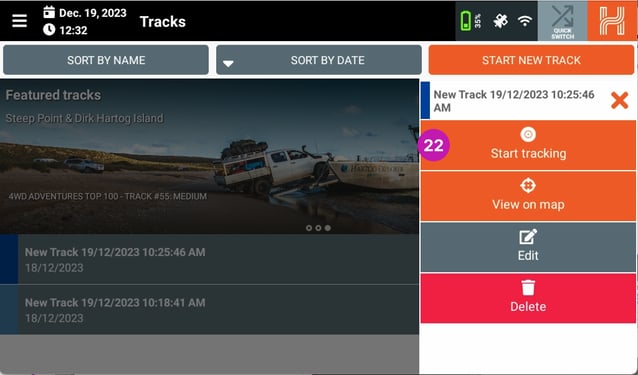
While the track is recording you will see a Recording [23] icon on the right of the track name.
To stop the recording click on the Stop tracking [24] option.
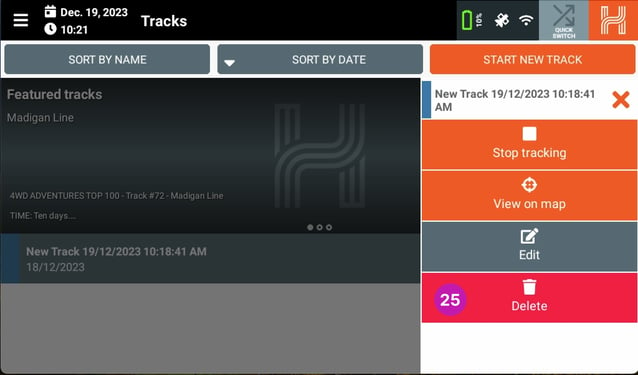
Deleting a Track
To delete a recorded track, go to the Tracks page and then select the track you wish to delete. When you have selected the track click on Delete [25] from the drop down options.
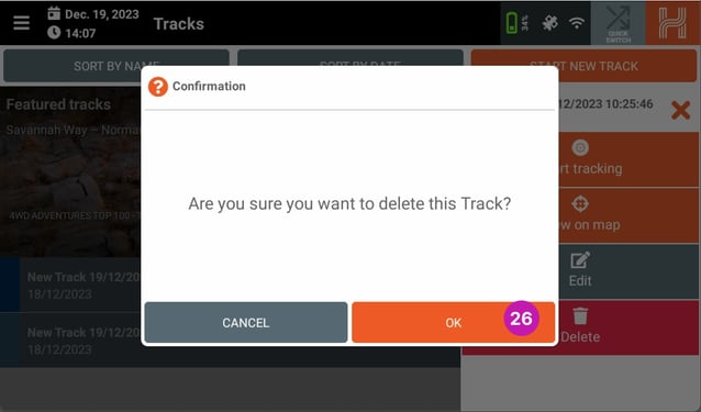
You will then get a popup box to confirm you want to delete this track, to confirm click OK [26].
Editing the Track Information
If you need to change the information associated with your Track after you have saved it, you can do this from the Track page.
From the Track page, click on the Track you wish to change the information for and then from the drop down banner click on Edit [27].

This will bring up the Track information, once you are finished editing the information click on Save [28] or Save & track [29] in the bottom banner.
Once you have either clicked Save or Save & track you will need to click OK [30] in the conformation window to proceed.
Waypoints
There are two ways in which you can add a new Waypoint.
Adding a Waypoint from the Waypoint Page
The first way is from the Waypoint page. To do this, firstly click on the Main Menu [1] icon in the top left hand corner.
From the drop down menu, click on the Waypoints [2] heading and then the waypoints page will load.
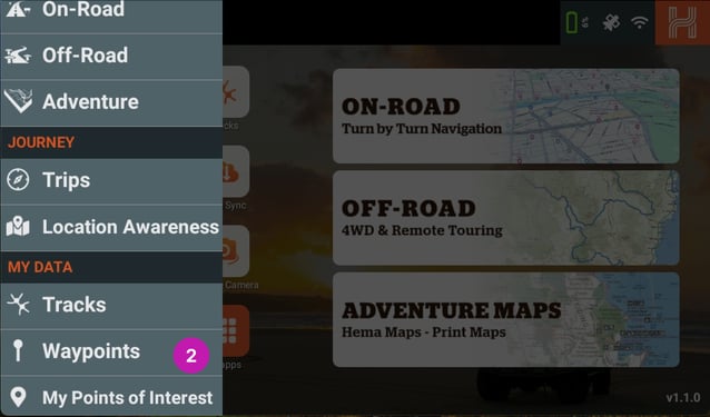
From the Waypoint page click on Add New Waypoint [3] button in the top right hand corner.
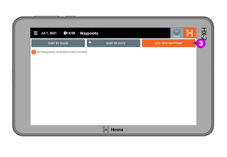
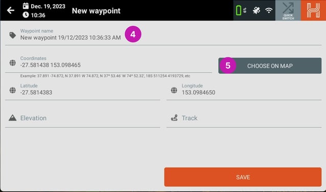
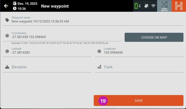
The New waypoint page will then open. From here you can give the waypoint a name [4], you can also enter the coordinates if you know them, or alternatively you can click on the Choose On Map [5] banner.
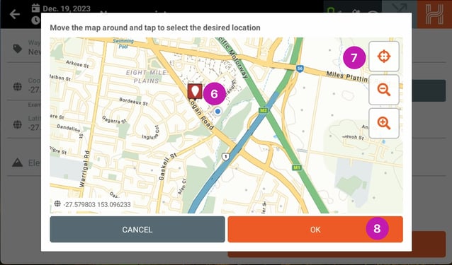
When you click on the Choose on Map button a popup up screen will appear and you can select the desired location for your waypoint by moving the Flag icon [6] to the desired location. You can also center to your current GPS location by clicking the Center Map [7] icon.
When you are satisfied that the Flag icon is in the correct place, click OK [8].
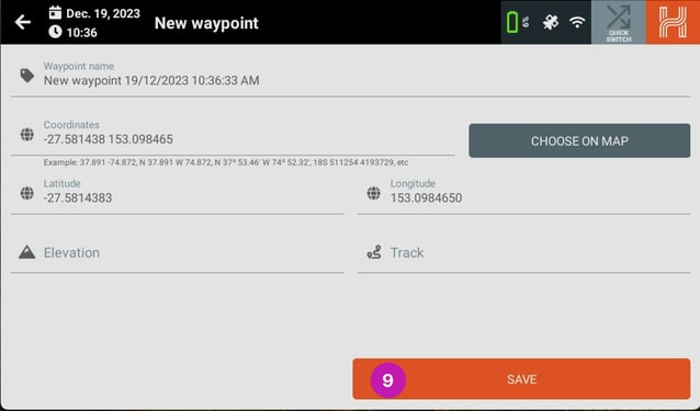
When you want to finish adding your new waypoint click Save [9].
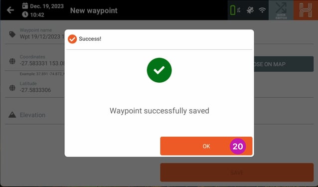
After you have clicked Save, you will get a notification that the waypoint has been successfully saved. To proceed please click OK [10].

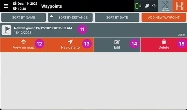
Once you have clicked OK, you will be returned to the waypoint page and you will see your new waypoint listed [11].
If you select the waypoint you have created, four options will appear.
- 12 View on map
- 13 Navigate
- 14 Edit
- 15 Delete
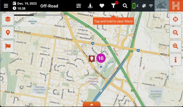
If you click View on map then you will show the selected waypoint on the Main Map [16].
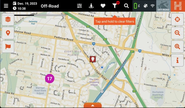
Adding a Waypoint from the Main Map
The second way is to add a waypoint from the Main Map.
If you want to add a waypoint from the Main Map, all you need to do is click and hold on the Main Map where you want the waypoint to be added [17]
You will then be asked to confirm that you would like to add a waypoint here.
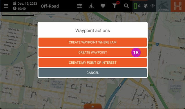
When you select Create Waypoint [18], the New waypoint page will then open. From here you can give the waypoint a name, you can also enter the coordinates if you know them, or alternatively you can click on the Choose on Map button as per the instructions above.
When you want to finish adding your new waypoint click Save [19].
When you click Save in the bottom panel, you will be notified that the process was successful.
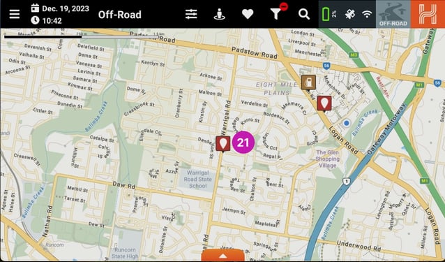
You will then see the waypoint display on the map [20].
Once your waypoint has been created you can then click on it and you will be given three options.
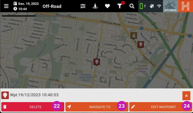
Deleting a Waypoint
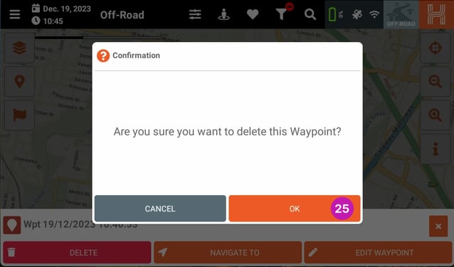
Pressing Delete [22] brings up a popup confirming the waypoint's deletion. Pressing OK [24] deletes the waypoint.
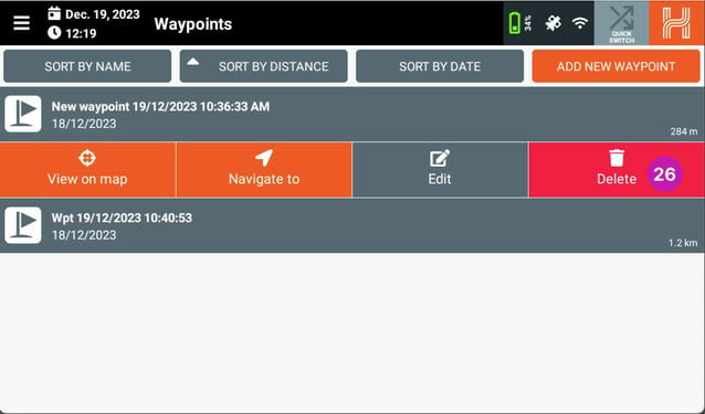
Alternatively, you can delete a waypoint from the Waypoint page. On the waypoints page, select the waypoint you would like to remove and then from the options that appear click on Delete [26].
You will then be asked to confirm that you would like to delete the waypoint, click OK [27] to delete the waypoint.

After you click Ok you will be returned to the waypoints page and the selected waypoint will be removed from the list.
Navigating to a Waypoint
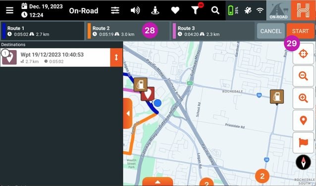
Clicking on the Navigate to [22] button will navigate you to the selected waypoint. To do this your HX-2+ will open the On-road mode and then will display some routing options [28]. Once you select the route option you would like, click on Start [29] to start the navigation.
Editing a Waypoint
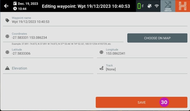
Clicking on the Edit [24] banner will let you edit the waypoint information. Once you have edited the information click on the Save [30] button.
HX-2+ Specifications
1. Product & Specifications
|
CPU |
Allwinner A1333 |
|
Operating System |
Android 10 |
|
Display |
7” 1024 x 600 IPS |
|
Touch Screen |
Capacitive Touch Screen, 5 points touch |
|
Ram |
4GB |
|
Internal Memory |
64GB |
|
Battery |
850mAh |
|
Battery life |
Up to 2 hours, depending on settings |
|
Physical buttons |
Power |
|
Wireless |
802.11 a/b/g/n/ac |
|
Other Communications |
Bluetooth® Ver. 5.2 |
|
Operating conditions |
-10°C to 60°C* (excluding battery charging) |
|
GNSS |
GPS + GLONASS + Galileo + QZSS |
|
Audio |
8Ω, 1W |
|
USB port |
USB-C x 1 |
|
Software Inclusions |
On-road Navigation - powered by HERE Technologies Off-road Hema Navigation - includes Hema Maps Explorer Map Adventure Maps - access to Hema Maps Print Maps (Raster) HX-2+ Application Updater Settings App Camera App |
|
Accessories |
Windscreen Mount, 12V/24V 2A Car Adapter USB-A to USB-C Lead Hard Carry Case |
|
Dimension |
182.63 x 107.63 x 23.1 |
|
Warranty |
3 years |
|
Optional Accessories |
WiFi Reversing Camera Sun Visor |
IMPORTANT PRODUCT INFORMATION
Safety notes and maintenance
1. Introduction
This section of the User Guide contains some general information and recommendations related to the use of your Hema HX-2+ (“the Product”).
2. Operating Environment
2.1. External Influences
Do not: (i) allow objects to drop onto the Product from above; (ii) place objects on top of the Product or rub the screen with abrasive materials or objects such as car keys etc; (iii) drop the Product: (iv) use sharp or abrasive objects to operate the touch screen other than the stylus designed for this purpose: (v) carry/transport flammable liquids, gases or explosives in the same compartment as the Product and its accessories.
Avoid prolonged use in high vibration and high shock environments. Wireless Products can interfere with the reception of satellite signals causing unstable signal reception. Some car audio systems can cause interference with the Product.
2.2. GPS
This system uses GPS signals produced and monitored by the United States government, who are solely responsible for the availability and accuracy of the system.
GPS satellite signals do not penetrate solid objects (apart from glass) and, therefore will not operate from within a building unless an external re-radiating GPS antenna is fitted. GPS signal reception may be impaired by dense obstacles above the ground such as tall buildings, trees, or extremely bad weather.
In order to operate efficiently, the Product should be positioned with a view to the open sky (through glass is acceptable). Glass with a metallic film, as fitted on some vehicles, may impair the GPS signal. An external automotive re-radiating GPS antenna may be required.
2.3. Temperature
Do not leave the Product lying or mounted on your dashboard where it will be exposed to extreme temperature conditions which can result in malfunctions and/or dangerous situations. The Product may be operated in a temperature range of -10°C to- 60°C (excluding battery charging).
Keep the Product away from moisture and excessive dust. The Product should be used in an atmospheric humidity (non-condensed) of 45% - 80% and stored in an atmospheric humidity of 30% - 90%.
Do not expose the Product to sudden and extreme temperature fluctuations. This may result in condensation forming within the Product causing malfunction or failure.
3. Safety while Operating the Product
IMPORTANT: Failure to adhere to the following guidelines may result in potentially hazardous situations and may result in serious injury or even Death.
Never operate/interact with the Product while you are driving. Use voice prompts while driving in order to minimise the time spent viewing the Product. Do not become distracted by the Product while driving. National road traffic regulations and local traffic conditions always take precedence over the instructions given by any navigation device.
Do not install the Product in such a manner as to obstruct the driver’s view of the road or interfere with the operation of a vehicle’s controls or safety features such as air bag systems.
The route calculated by the Product is a suggested route and should be used for reference only. It is not a substitute for alert driver behaviour and common sense. Drivers must continue to pay attention to all road regulations and hazards regardless of instructions from the Product.
3.1. Safety While Travelling
The Product is a valuable aid for navigation. It should not be used as a replacement for hard-copy maps and other traditional navigational aids while travelling, especially in remote areas. Always ensure that you have adequate backup systems in place to ensure your personal safety.
Local conditions can change rapidly, therefore it is recommended to seek advice from local authorities and pay attention to all road signs, particularly where those signs advise of serious hazards, such as local flooding etc.
3.2. Battery
This product uses a rechargeable lithium-polymer battery which is not user serviceable and not user replaceable. Failing to adhere to these guidelines may reduce the life expectancy of the battery or present the risk of electrolyte leak, explosion and fire resulting in chemical burn, damage and/or Injury.
3.3 Cleaning the Unit
The Product casing can be cleaned using a cloth slightly dampened with water and a mild detergent and then wiped dry. Care must be taken not to let moisture into the speaker holes or any of the ports, jacks and slots on the Product.
The touch screen may be cleaned using lint free or microfiber cloths. Isopropyl alcohol or water may be applied to the cloth where required to gently wipe the touch screen only.
Do not use harsh or abrasive cloths and avoid the use of chemical cleaners or solvents as these can damage the Product.
3.4 Avoiding Theft
To avoid theft, remove the Product and mount from sight when not in use. Remove the residue left on the windscreen by the suction mount.
|
Adapter |
Only use the original 12/24V 2A car adapter supplied with the Product. Use of nonstandard parts or accessories may result in malfunctions and/or severely damage the Product and may void your warranty. |
|
Environment |
Do not expose the Product to a damp, wet or corrosive environment. Do not expose the Product to excessive pressures, heat sources, high temperatures, or extreme sunlight conditions, such as an unattended vehicle on a hot day. Do not expose the Product to operating temperatures outside of the recommended range of 0°C - 60°C and storage temperatures outside of the recommended range of -20°C - 60°C (excluding battery charging). |
|
Care |
There are no user serviceable parts in the Product. Do not open the Product. Do not pierce, open or dismantle the battery. If the battery leaks and you come into contact with the liquid, thoroughly rinse the contaminated area with water. Seek medical attention if you suffer any continued symptoms where the liquid has come into contact with your skin. |
ONE YEAR LIMITED WARRANTY STATEMENT
1. What is provided under the Warranty
Hema warrants that the Product, Hema branded accessory and included battery you have purchased from Hema or Hema Authorised Reseller is free from defect in materials or workmanship under normal use for a period of 12 months from date of purchase (“Warranty”).
This expressed limited Warranty extends only to the original purchaser and cannot be transferred to anyone.
If the Product fails during normal and proper use within its warranty period, Hema will repair or exchange the faulty parts within the Product, or the Product itself (“Warranty”). Goods presented for repair may be replaced by refurbished goods of the same type rather than being repaired. Refurbished parts may be used to repair the product. Ownership of items is surrendered to each party on exchange. Repair or exchange is subject to the original item being genuine and unaltered.
To obtain warranty service, during the warranty period, your sales receipt or proof of purchase is required to receive warranty service.
2. What is not provided under the Warranty
You must read and follow all set-up and usage instructions in the applicable user guide and/or manuals enclosed. If you fail to do so, this Product may not function properly and you may lose data or suffer other damage. Hema, its affiliates and suppliers do not warrant that operation of this Product will be uninterrupted or error free.
All warranties, conditions and liability implied by law that may be excluded are hereby excluded and Hema shall not be liable for any direct or indirect loss or damage of any kind arising from the goods or your use of them (including but not limited to loss of profits and incidental or consequential loss or damage).
For the absence of doubt, this warranty does not cover:
- failures due to abuse, misuse, accident or unauthorised alterations or repairs, damage caused by improper installation or improper connection to an automobile (“vehicle”) - this includes hardwiring the 12/24v adaptor and use of any other charger not approved in writing by Hema;
- damage caused by failure to heed the guidelines outlined in the Safety Notes and Maintenance section of this booklet;
- damage caused by exposure to excessive heat beyond the stated heat tolerance or accidental damage caused by dropping the Product or otherwise;
- loss or corruption of Micro SD card data, users USB memory stick data or Resident Flash data other than that supplied as standard with the Product;
- damage caused by improper installation or improper connection to a computer or automobile. This includes modifying, bypassing or hardwiring the 12/24V adaptor and use of any other charger not approved in writing by Hema;
- damage caused by an external electrical fault or impact;
- damage caused by accident, misuse, abuse, neglect or improper maintenance, including fracture or damage to the LCD (screen), casework, cables, 12/24V Adaptor, and plugs;
- damage from use outside usage or storage parameters set forth in the Product’s User Guide;
- damage from use of accessories not manufactured or sold by Hema;
- damage to or loss of any programs, data or removable storage media, or costs of recovering such programs or data;
- product purchased from anyone other than Hema, Hema Authorised Resellers or by way of auction;
- product purchased outside of Australia;
- modifications to the Product not approved in writing by Hema;
- service made necessary by use of third party products not approved in writing by Hema;
- routine cleaning, or normal cosmetic and mechanical wear and tear or any other event, act, default or omission outside Hema’s control;
- damage or loss during transit to Hema, Hema Authorised Service Provider or Hema Authorised Reseller. Any service or repair for items not covered by this Warranty shall be at Hema’s or its Authorised Service Provider’s rates and terms then in effect.
3. Consumer Guarantees (Australia only)
Consumer Guarantees apply to goods bought on or after 1 July 2020 by a consumer from a Supplier, in the course of a normal trade (not by way of auction where the auctioneer acts as agent of the owner(s)), and where the goods are normally used for personal, domestic or automobile purposes. Our goods come with guarantees that cannot be excluded under the Australian Consumer Law.
You are entitled to a replacement or refund for a major failure and for compensation for any other reasonably foreseeable loss or damage.You are also entitled to have the goods repaired or replaced if the goods fail to be of acceptable quality and the failure does not amount to a major failure.
This Warranty is not intended to and does not limit your rights with respect to the Consumer Guarantees (in Australia). The benefits to the consumer given by the warranty are in addition to other rights and remedies of the consumer under a law in relation to the goods or services to which the warranty relates.
To the extent permitted by law, the warranties and remedies contained herein are exclusive and in lieu of all other warranties expressed, implied, or statutory, including any liability arising under any warranty of merchantability or fitness for a particular purpose, statutory or otherwise.
4. Procedure for claiming warranty
Step 1: Contact your Authorised Hema Reseller or the place of purchase for service or advice. Alternatively visit Hema’s website for support and service Information.
Step 2: If it is necessary for you to send your Product directly to Hema, you are required to submit a Support Request from the Hema website or contact Hema by phone (+61 7 3340 0000), in order to obtain a Return Authority or Ticket Number. This ticket number must be clearly visible on the outside packaging of the Product in order to be processed.
The cost of postage to Hema will be borne by the sender. The cost of return postage to the sender will be borne by Hema.
Ensure that you provide your return shipping address and daytime telephone number so that Hema can return the Product to you.
Repairs or replacement under Warranty will be made at no charge to the customer for parts or labour, provided that the customer shall be responsible for any transportation costs.
5. Protection of Stored Data
Repair to the goods may result in loss of the data. It includes, for example, waypoint, track and route data, point of interest data, songs, photos, telephone numbers, addresses and electronic documents. Hema recommends that you backup and secure your data prior to sending the goods for repair or Service.
To protect your important data, Hema recommends that you make periodic back-up copies of all the data stored in flash memory or other storage devices as a precaution against possible failures, alteration, or loss of the data. If your data is altered or lost due to any trouble, failure or malfunction of the flash memory or other storage devices and the data cannot be recovered, Hema shall not be liable for any damage or loss of data, or any other damage resulting from this. When copying or transferring data, please be sure to confirm whether the data has been successfully copied or transferred. Hema disclaims any liability for the failure to copy or transfer the data correctly, or the security of your data.
6. Critical Applications
The Product you have purchased is not designed for any “critical applications”. “Critical applications” means, medical applications, emergency services applications, commercial transportation, or any other applications where product failure could lead to injury to persons or loss of life or catastrophic property damage.
Accordingly, Hema, its affiliates and suppliers disclaim any and all liability arising out of the use of the Product in any critical applications. If you use the Product in a critical application, you, and not Hema, assume full responsibility for such use.
7. Warrantor
The Warranty is granted by Hema Maps Pty Ltd, 21 Brandl St, Eight Mile Plains, QLD 4113, ABN 34 010 601 911 (“Hema”). You can reach our customer support at phone number +61 7 3340 0000 during business hours 9:00 am to 4:00 pm AEST (Monday to Friday). Hema’s customer support can also be reached by email at info@emprisegroup.com.au.
8. Hema Online Support
Technical support is available electronically on Hema’s website www.hemamaps.com, here you will find answers to commonly asked technical questions plus downloadable software and utilities.
9. Hema Support Centre
Hema provides limited complimentary technical phone support for 90 days following the new purchase of your Product. If you seek Hema technical phone or email support beyond this period or require assistance to install, configure or troubleshoot the Product, charges may apply at the then prevailing rates.
If the warranty service provided does not meet the offer outlined in this document, please detail your concerns to the Customer Service Manager, Hema Support, by a letter addressed as follows or by email:
info@emprisegroup.com.au
Hema Maps Pty Ltd
Customer Service Manager
PO BOX 4365 Eight Mile Plains QLD 4113 Australia
10. Privacy Statement
Information supplied by you is used by Hema to process your request and to perform a warranty action. No information will be disclosed without your permission. You have a right of access to information which Hema may hold about you. You may request the correction of that information. Hema’s Privacy Policy can be accessed at https://www.hemamaps.com/policies/privacy-policy.
HX-2+ TERMS AND CONDITIONS OF USE
The following are the Terms and Conditions of Use of the Hema Software. Please read these Terms and Conditions carefully. If You use the Hema Software, You will be bound by these Terms & Conditions of Use. The Hema Software (“the Software”) is licensed, not sold, to You for use only under the terms of this license. It contains warranty and liability disclaimers
which You should read.
The Software and the Data are copyrighted works, protected by law, violation of which may result in civil or criminal liability. Access to the Software requires you to have internet access. Internet services may not be available at your present or intended location or may be very expensive.
1. Scope of Licence granted
Subject to the usage rules and restrictions in clauses 2 and 3, we grant You a non-exclusive, non-transferable license to:
- Use the HX-2+ licence and Software thereon;
- Backup the Software and Your Data from any device that You own to the Hema Cloud or to any personal computer or device that You use, to keep for Your use. You must not give the backup or copy to anyone else and any such backup or copy is governed by these Terms and Conditions.
2. Usage Rules
- Always be prepared, drive carefully and travel responsibly. Location data and road conditions are constantly changing, and the Software may contain errors, omissions or inaccuracies. Location data or navigational information is provided as a general guide only and is not intended to be relied upon as a sole means of navigation or in situations where precise
location information is needed, or where erroneous, inaccurate or incomplete data may lead to death, personal injury, property or environmental damage. You must make Your own enquiries in relation to conditions and the availability of fuel, drinking water, supplies and services. Depiction of a road or track in the Software is not an assurance of safety or manner of passage or public right of way and information contained in the Software does not replace traffic signs, lights, road markings, speed limits and other road rules.
- You must take care of Your own personal safety, and (if applicable) obey the road rules, at all times. Do not operate the Software while driving. Do not use or operate any mode of transport or attempt any journey while under the influence of alcohol or other substances.
- You acknowledge that the Content within the Software is for planning purposes only and You should make Your own enquiries and exercise Your own judgment in relation to weather conditions, construction, road closures or other events that may impact on the journey You are undertaking.
- You acknowledge that some content within the Software is protected by applicable intellectual property and other laws, including but not limited to copyright, and that You will not use such proprietary content in any way whatsoever except for permitted use under these Terms and
Conditions. You also acknowledge that some content may be provided under licence from third party providers and this content is subject to the same intellectual property laws.
- The Software may enable access to Hema Maps and other third party maps, content, services and web sites (such as HERE maps, Map box, weather data and the Hema Cloud). If these are provided, they are done so solely as a convenience to You and may be withdrawn at
any time. Access to these services may require internet access, which You will need to arrange and pay for Internet services may not be available at Your location or may be very expensive. Because of the nature of the internet, it is possible that these sites may contain computer viruses or material which You may find offensive. Hema Maps does not warrant or endorse, and disclaims liability to You or any other person, for any third party maps, content, services, and web sites. Hema Maps reserves the right to change content or options (including eligibility for
particular features) without notice.
- The provision and terms of use of the Hema Cloud will be subject to the Hema Cloud EULA as amended from time to time and may be subject to restrictions on use, content and size as Hema Maps shall determine in its sole discretion.
3. Services provided by Hema Maps
- Hema Maps reserves the right to outsource the provision of services to third-parties where it is necessary including the provision of Hema Cloud Services.
- You agree that the form and nature of the Hema Software may change from time to time without prior notice being given to You.
- Hema Maps reserves the right to change, suspend, remove or disable access to any of the services contained in the HX-2+ at any time without notice.
- Hema Maps may also impose limits on the use of or access to the Hema Cloud Services from within the Software.
4. Licence restrictions
- This license does not permit You, and You agree that You will not (except where we give our express written consent or You are expressly permitted by law to):
- commercialise, or attempt to commercialise, or derive any monetary reward or commercial benefit (whether a fee is charged for it or not) from the use or sale of the Software, the Data or user data (including any Data You or other users have created or stored in the Software or Hema Cloud or any part of it (including but not limited to any location data or other geographical information contained in, or copied or obtained from, the Software whether modified or not). This includes but is not limited to supplying part or all of the content into an open source or not for profit database e.g.. crowd-sourcing, open street map;
- use the Software on any other device. You will not distribute or make the Software available over a network where it could be used by multiple devices at the same time;
- digitise or edit the Software or take a digital or analogue image, photograph or screenshot of the Software, other than for the purpose of seeking technical support from us;
- d. remove, obscure or interfere with any copyright notice, trade mark, warning or disclaimer contained in the Software;
- use all or any part of the Data to make a map, guide, publica3on, website, navigational aid or publication for the purpose of supply to others for commercial benefit or promo3on, whether a fee is charged for it or not;
- transfer, give, assign, rent, lease, sell, charge, exchange, adapt, decompile, disassemble, create a derivative product or otherwise deal with the Software other than in the normal course of use, and subject to this to these Terms & Conditions, as amended from time to time;
- reproduce in any way, copy or extract the Software or the Data, in whole or in part and give, sell, rent, market or distribute it to anyone else;
- copy the Software or any data stored in the Hema Cloud onto another storage device other than as expressly permitted by clause 1 sub clause 1 section (b);
- without limiting any of the paragraphs (e) to (h) above, copy, or attempt to copy, the location data, maps points/places of interest (POI’s), names, places, symbols, road markings, layout or other geographical information contained in the Software, or use such information or data as a reference to make any other product, or otherwise extract, reverse engineer, decompile, modify, dissemble, attempt to derive the source code of, modify, or create or attempt to create a new or derivative works of or from the Software;
- use the Software in a manner contrary to any agreement You have with any third party;
- sub license or assign Your rights under this license to anyone.
- You acknowledge that the Software and its contents, including the Data, contain valuable intellectual property. We may impose further restrictions on Your use of the Software or the Data at any time, as we deem to be reasonably necessary to protect our intellectual property rights, by the giving of notice to You.
- The Software is protected by copyright law and international treaties. Unauthorised reproduction or distribution of this Software, or any portion of it, may result in severe criminal and civil penalties and will be prosecuted to the maximum extent possible under law.
5. Ownership
Subject to this clause 5:
- Hema Maps expressly reserves all copyright and any other intellectual property rights to the Software, the Data, including (without limitation) places of interest (POIs), and any or all maps created or published by Hema Maps, and the Hema Cloud and only grants You a limited licence to use the Software and the data in the manner permitted by these Terms & Conditions.
- Other than as specified herein, You agree that Hema Maps owns the intellectual property rights to the Data, whether in its original form or as modified, printed and/or copied by You.
- Subject to clauses 5 sub-clause 1 and clause 5 sub-clause 2 above, You own the content (excluding the Data in its original or modified form) that You create using the Software (e.g. Your photographs). However, You grant us a non exclusive, perpetual, transferable, sub-licensable, royalty-free, worldwide license to use any IP content that You input or generate by using the Software, including (but not limited to) reviews, comments, photos, places of interest, tracks, way points, or other personal information or by-products of the Software.
- HERE North America LLC is the publisher of the base data used under licence for the Street, Terrain and Satellite Maps and is the owner of the intellectual property rights within, which are used in the product under licence.
- You acknowledge that Hema Maps is the sole owner and user of the Trademarks, name(s) or words Hema, Hema Maps, Hema Navigator, Hema Maps, Hema GPS, Hema 4WD Explorer, Hema Navigator Explorer, Hema Explorer, Map Patrol, “Hema Maps will get You there”, and “Prepared to Explore.” the Hema corporate logo and the Hema “H” icon and You must not use our names or trademarks without our express written permission.
- This product includes Here Maps SDK provided by HERE North America LLC and the Map box SDK provided by Map box.
- Contains information licenced from Open Street Maps, Geoscience Australia, Camps Australia Wide, Landgate (Western Australian Land Information Authority) and other State Government bodies.
- Hema Maps may add other licenced software from time to time.
6. Limited warranties
Save to the extent prohibited by law:
- while the Software has been produced and supplied in good faith, Hema Maps makes no warranty or representation about the availability, accuracy, completeness, reliability or currency of the Software or the location data contained therein;
- the Software and the Data is provided “as is” and “as available”, with all faults and without warranty of any kind. Hema Maps disclaims all other warranties, either express or implied, including warranties of merchantability, fitness for purpose or for a particular purpose and noninfringement of third party rights unless such warranties cannot be excluded by law. Hema Maps does not warrant against interference with Your enjoyment of the Software, that the Software will meet Your requirements or that the operations of the Software itself or in conjunction with other products will be uninterrupted or error free.
- You expressly acknowledge and agree that use of the Software is at Your sole risk and that the entire risk as to suitability, satisfactory quality, reliability, performance, accuracy and effort is with You;
- although Hema Maps or a third party may provide technical support, Hema Maps does not warrant that technical support will be provided for the Software;
- no oral or written information or advice given by Hema Maps, agents or employees shall create or extend existing warrants. You must not rely on any such information or advice unless in writing and signed by an authorised representative of Hema Maps.
- For the absence of doubt, your statutory rights remain valid and in force and, in the event of inconsistency between these Terms and Conditions and your statutory rights, your statutory rights prevail to the extent of the inconsistency.
7. Limitation of liability
- This Software displays, includes or makes available content, data, information, applications collected by or supplied by third parties, which may contain errors, omissions, inaccuracies or faults. By using the Software, You acknowledge and agree that Hema Maps is not
responsible for examining or evaluating the content, quality, currency, accuracy, completeness, legality, or any other aspect of such third party data.
- You use and rely on the Software entirely at Your own risk and should not solely rely on the results or information obtained from the Software for any purpose, including navigation.
- To the extent not prohibited by law, the liability of Hema Maps for any breach of an express, statutory or implied warranty shall be limited, at its option, to the cost of replacement of the Software or a refund of the price paid by You.
- To the extent not prohibited by law, Hema Maps shall not be liable for any loss or damage to person or property, or any incidental, special, indirect or consequential damages whatsoever, including without limitation, loss of income, loss of revenue, trade, business, information or profits or any other loss arising from the installation or use of the Software or reliance upon any Data (irrespective of whether or not the Data is used in any navigation system or for the purposes of navigation) whether based on breach of contract, tort (including negligence),
product liability or otherwise.
- Hema Maps shall not be liable for any information, advice or technical support given by a third party unless in writing and signed by an authorised representative of Hema Maps.
- It is Your responsibility to update the Software with the updates provided by Hema Maps from time to time. Hema Maps shall not be liable for Your reliance or use of an out of date version of the Software.
8. General
- This agreement incorporates the terms of the Hema Cloud EULA (as amended from time to time). It otherwise makes up the entire agreement between the parties regarding the Software, and supersedes any prior agreements.
- This agreement incorporates the terms of the HERE Maps End User Terms and the Map box End User Terms, as amended from time to time.
- If any portion of this agreement, or the incorporated agreement(s), is found to be unenforceable, the remaining portion will remain in full force and effect.
- If Hema Maps fails to enforce any terms of this agreement, this will not
constitute a waiver.
- These Terms and Conditions (“this agreement”) shall be governed by and interpreted in accordance with the laws of the State of Queensland, Australia. You agree to be subject to the legal jurisdiction of the State of Queensland, Australia.
- You will not use or attempt to use the Software to do anything that infringes or violates someone else’s rights or otherwise violates the law.
9. Termination
- This agreement remains in force until Your rights under this license are terminated by You or us. We may terminate Your license at any time if You fail to comply with any term(s) of this license.
- Upon termination of the license, You must cease to use the Software and the Data and destroy all Your copies of the Software and the Data.
- Upon termination of this agreement, the license in Clause 1 will immediately end but otherwise the legal rights, obligations and liabilities that you have to us to remain unaffected.
10. Definitions
- “Hema Maps”, “we” or “us” means Hema Maps Pty Ltd ACN 010 601 911, whose principal place of business is First Floor, 21 Brandl St, Eight Mile Plains, Queensland, Australia,
4113 and the licensor of the Product for the purpose of this agreement.
- “You” or “Your” means the individual or organisation purchasing the Product, and the licensee for the purpose of this agreement.
- “the Software” means the Hema Software and all the Software and Data supplied or contained therein, or anything provided ancillary thereto, including cloud based storage. For the purpose of this licence agreement, “the Software” includes the product supplied to You, the Data, updates (if any), or any part thereof.
- “Data” means the information and materials embodied in machine readable media on the Software including, but not limited to, maps, location data, artwork, illustrations, photographs, images and text.
- “Hema Cloud” means any cloud based service offered by Hema Maps Pty Ltd in connection with the Software.
HEMA CLOUD TERMS & CONDITIONS OF USE
The following are the Terms and Conditions of Use of the Hema Cloud and associated Software (the “Service”). Before using the Service. please read these Terms and Conditions carefully as well as all rules and policies related to the Service (including usage restrictions and other
conditions or procedures that we post or update on or through the Service or on our website www.hemamaps.com.au), the Hema Maps Privacy Policy and Hema Software (“the Software”) Terms and Conditions of Use. If You use the Service, You will be bound by these Terms & Conditions of Use.
READ AND OBEY THE IMPORTANT SAFETY RULES AT THE END OF THESE CONDITIONS. ACCESS TO THE HEMA CLOUD REQUIRES YOU TO HAVE INTERNET ACCESS. INTERNET SERVICES MAY NOT BE AVAILABLE AT YOUR PRESENT OR INTENDED LOCATION OR MAY BE VERY EXPENSIVE.
1. The Service
- The Service provides features and functionality that allow You to store, retrieve, manage and use Your stored trips, tracks, POI data and photos within the Software. By using the Service, You are promising us to store, manage and use Your data on Your behalf within the Software or Service.
- The Service may offer free and paid plans, which have different storage capacity limits.
- The storage limit for any free Service Plan may be amended or withdrawn by us at any time.
- Where Your use of the Service has or will exceed the free data storage allowance, You may purchase additional Service Plans for a fee, and subject to the terms and conditions, as published from time to time on our website www.hemamaps.com.au.
2. Usage Rules
- Subject to the usage rules and restrictions in this agreement, we grant You a non-exclusive, non-transferable right to use the Service for Your personal, non-commercial, recreational use. We do not grant You the right to use the Service for the purposes of redistributing or otherwise
using any of our content for Your own business purposes unless You are expressly licensed to do so by us in writing.
- You may use the Service only for personal, non-commercial use. You may not use the Service to store, transfer or distribute content of or on behalf of third parties, to operate Your own content application or service, to resell any part of the Service or for any form of unlawful file sharing.
- You are solely responsible for Your data stored within the Service, including for ensuring that it has been lawfully acquired, for complying with all applicable copyright and other laws and licenses, and for maintaining a back-up of it.
- You will be required to choose a user name and/or a password when registering with the Service. You are responsible for keeping Your login credentials secret. You accept that You will be personally liable for all activities conducted and transactions concluded using Your login credentials.
- You may need to register the devices You use with the Service, and we may limit the number of devices You can register and the number of devices from which You can use the Service at any one time. There may be limits on the types of content You can store using the Service, such
as file types we don’t support. If You exceed Your Service Plan’s storage limit, including by downgrading or not renewing Your Service Plan, You may no longer be able to access Your data. We may impose other restrictions on Your use of the Service.
- We may use, access and retain Your data in order to provide the Service to You and enforce the terms of the Agreement, and You expressly give us all permissions we need to do so. These permissions include, for example, the rights to copy Your data for backup purposes and access to Your data to provide technical support. However, we do not guarantee You access to Your data and You are responsible for maintaining Your own backup. Hema Maps respects Your privacy and Your data is subject to the Hema Maps Privacy Policy, located at www.hemamaps.com.au/en/Policies/Privacy.
- We do not monitor, edit, control or filter the content submitted to this Service by our users. Such content does not represent our views and we have not authorized or endorsed such content. Where it contains location data or information, it may be inaccurate.
- Notwithstanding that the Service may furnish You with links to third party websites or services and that some third party websites or services may contain links to this Service we do not control, endorse or approve the activities or content of any such third party websites or
services. Please contact the relevant web site or service provider if You have a complaint about the activities or contents of a third party website or service.
- You may not use Your access to this Service in a manner that would bring us, our business and/or any of our personnel into disrepute. Furthermore, You may not access this Service for unlawful purposes or use it in a manner which infringes our rights or the rights of any other
person or restricts or inhibits the use of or enjoyment of this Service by any other person. In this regard, You must comply with the laws, regulations and codes of conduct applicable to Your use of this Service. You may not post or transfer any material to our Service that is unlawful
or violates any third party’s rights or which is obscene, incites harmful behaviour, misleading, inaccurate, defamatory, illegal, in breach of any copyright or other intellectual property right, constitutes unsolicited commercial communications, or is damaging to data, Software or the
performance of our Service. We may remove any content You have submitted to this Service and/or suspend Your access to any part of this Service at any time without notice.
3. Services Provided by Hema Maps
- The Service may utilise data and related content on Your device and collect other information that may be used to identify Your data and related content including metadata from Your device. The Service may provide Hema Maps with information relating to Your use and the
performance of the Service, as well as information regarding the devices on which You download and use the Service. For example, this information may include the device type, mobile network connectivity, IP address of the device, information about Your internet service
provider, information about when the Software is launched, individual session lengths for use of the Service, information about the content used through the Service, or occurrences of technical errors. Any information we receive is subject to the Hema Maps Privacy Policy, located at www.hemamaps.com.au/en/Policies/Privacy.
- Hema Maps reserves the right to outsource the provision of services to third-parties where it is necessary including the provision of Cloud Services.
- You agree that the form and nature of the Service may change from time to time without prior notice being given to You.
- Hema Maps reserves the right to change, suspend, remove or disable access to any of the Services at any time without written notice.
4. Usage restrictions
- You may not, and You will not encourage, assist or authorize any other person to (a) modify, reverse engineer, decompile or disassemble, or otherwise tamper with, the Service or (b) circumvent, disable or dupe any methodology we use to identify and use data from Your account
and include it within our service or database.
- Without limiting clause 4 sub-clause 1 above, this Service does not permit You, and You agree that You will not (except where we give our express written consent or You are expressly permitted by law):
- commercialise, or attempt to commercialise, or derive any monetary reward or commercial benefit (whether a fee is charged for it or not) from the use or sale of the Service, the Data or user data (including any Data You or other users have created or stored in the Software or Hema Cloud) or any part of it (including but not limited to any location data or other geographical information contained in, or copied or obtained from, the Software whether modified or not). This includes but is not limited to supplying part or all of the content into an open source or not for profit database e.g crowd-sourcing, open street map;
- use the Service on any device other than a device that is owned or controlled by You. You will not distribute or make the Service available over a network where it could be used by multiple devices at the same time;
- digitise or edit the Service or take a digital or analogue image, photograph or screenshot of the Service, other than for the purpose of seeking technical support from us;
- remove, obscure or interfere with any copyright notice, trademark, warning or disclaimer contained in the Service;
- use all or any part of the Data to make a map, guide, publica3on, website, navigational aid or publication for the purpose of supply to others for commercial benefit or promo3on, whether a fee is charged for it or not;
- transfer, give, assign, rent, lease, sell, charge, exchange, adapt, decompile, disassemble, create a derivative product or otherwise deal with the Software other than in the normal course of use, and subject to this to these Terms & Conditions, as amended from time to time;
- reproduce in any way, copy or extract the Service or the Data, in whole or in part and give, sell, rent, market or distribute it to anyone else, whether a fee is charged for it or not;
- copy the Service or any data stored in the Hema Cloud onto another storage device other than as expressly permitted by clause 4 sub-clause 2;
- without limiting any of the paragraphs (e) to (h) above, copy, or attempt to copy, the location data, maps points/places of interest (POI’s), names, places, symbols, road markings, layout or other geographical information contained in the Software or Service, or use such information or data as a reference to make any other product, or otherwise extract, reverse engineer, decompile, modify, dissemble, attempt to derive the source code of, modify, or create or attempt to create a new or derivative works of or from the Software or Service;
- use the Service in a manner contrary to any agreement You have with any third party;
- Sub license or assign Your rights under this license to anyone.
- You acknowledge that the Service and any related content (if applicable) and any Data or content we provide to You contain valuable intellectual property. You also acknowledge that some content may be provided under licence from third party providers and this content is subject to the same intellectual property laws. We or our suppliers may impose further restrictions on Your use of the Service, the Software (if applicable) or the Data at any time, as we or they may deem to be reasonably necessary to protect our respective intellectual property
rights, by the giving of notice to You.
- The Service, the Data and the Software is protected by copyright law and international treaties. Unauthorised reproduction or distribution of this Software, or any portion of it, may result in severe criminal and civil penales and will be prosecuted to the maximum extent possible under law.
5. Ownership:
Subject to this clause 5:
- Hema Maps expressly reserves all copyright and any other intellectual property rights to the Software, the Data, including (without limitation) places of interest (POIs), and any or all maps created or published by Hema Maps and the Hema Cloud and only grants You a limited licence to use the Software and the Data in the manner permitted by these Terms & Conditions.
- HERE North America LLC is the publisher of the base data used under licence for the Street, Terrain and Satellite Maps and is the owner of the intellectual property rights within, which are used in the product under licence.
- Contains information licenced from Open Street Maps, Geoscience Australia, Camps Australia Wide, Landgate (Western Australian Land Information Authority) and other State Government bodies.
- Hema Maps may add other licenced software from time to time.
- Other than as specified herein, and without limiting clause 5 sub clause 1, You agree that Hema Maps owns the intellectual property rights to the Data, whether in its original form or as modified, printed and/or copied by You.
- Subject to clause 5 sub clause 1 and clause 5 sub clause 2 above, You own the content (excluding the Data in its original or modified form) that You create using the Service (e.g. Your photographs). However, You grant us a non-exclusive, perpetual, transferable, sub-licensable, royalty free, worldwide license to use any IP content that You input or generate by using the Service, including (but not limited to) reviews, comments, photos, places of interest, tracks, waypoints, or other personal information or by-products of the Service.
6. Limited warranties
Save to the extent prohibited by law:
- while the Service has been produced and supplied in good faith, Hema Maps makes no warranty or representation about the availability, accuracy, completeness, reliability or currency of the Service;
- the Service is provided “as is” and “as available”, with all faults and without warranty of any kind. Hema Maps disclaims all other warranties, either express or implied, including warranties of merchantability, fitness for purpose or for a particular purpose and non-infringement of
third party rights unless such warranties cannot be excluded by law. Hema Maps does not warrant against interference with Your enjoyment of the Service, that the Service will meet Your requirements or that the operations of the Service itself or in conjunction with other products
will be uninterrupted or error free.
- You expressly acknowledge and agree that use of the Service is at Your sole risk and that the entire risk as to suitability, satisfactory quality, reliability, performance, accuracy and effort is with You;
- although Hema Maps or a third party may provide technical support, Hema Maps does not warrant that technical support will be provided for the Service;
- no oral or written information or advice given by Hema Maps, agents or employees shall create or extend existing warrants. You must not rely on any such information or advice unless in writing and signed by an authorised representative of Hema Maps.
7. Limitation of liability
- The Service displays, includes or makes available content, data, information, applications collected by or supplied by third parties, which may contain errors, omissions, inaccuracies or faults. By using the Service, You acknowledge and agree that Hema Maps is not responsible for examining or evaluating the content, quality, currency, accuracy, completeness, legality, or any other aspect of such third party data.
- You use and rely on the Service entirely at Your own risk and should not solely rely on the results or information obtained from the Service for any purpose, including navigation.
- To the extent not prohibited by law, the liability of Hema Maps for any breach of an express, statutory or implied warranty shall be limited, at its option, to the cost of replacement of the Service or a refund of the price paid by You.
- To the extent not prohibited by law, Hema Maps shall not be liable for any loss or damage to person or property, or any incidental, special, indirect or consequential damages whatsoever, including without limitation, loss of income, loss of revenue, trade, business, information
or profits or any other loss arising from the installation or use of the Service or reliance upon any Data (irrespective of whether or not the Data is used in any navigation system or for the purposes of navigation) whether based on breach of contract, tort (including negligence),
product liability or otherwise.
- The Service may enable access to maps, content, services and websites provided by us or third parties. If these are provided, they are done so solely as a convenience to You and may be withdrawn at any time. Access to these services may require internet access, which You will
need to arrange and pay for. Internet services may not be available at your location or may be very expensive. Because of the nature of the internet, it is possible that these sites may contain computer viruses or material which You may find offensive. Hema Maps does not warrant or
endorse, and disclaims liability to You or any other person, for any third party maps, content, services, and web sites.
- Hema Maps shall not be liable for any information, advice or technical support given by a third party unless in writing and signed by an authorised representative of Hema Maps.
8. Collection of information and privacy policy
- You agree that we may collect and use technical data and related information, including information about Your device, system or application Software to facilitate the provision of the Software or Service support, Software updates and other services (if any) in connection with the Service or Software. We may use this information, so long as it is in a form that does not personally identify You, to improve our products or services and so long as our use in accordance with our Privacy policy as updated from time to time, www.hemamaps.com.au/en/Policies/Privacy.
- By submitting any ideas, reviews, comments, corrections, feedback and/ or proposals (“Feedback”) to Hema through the Service or Software or other means, You acknowledge and agree that the Feedback is Your own work, and we may freely use, distribute, exploit and further
develop, modify or use it as we see fit without any obligation to compensate You (just as You have no obligation to offer Feedback), and that Hema may already have similar development ideas to the Feedback.
9. General
- This Agreement shall be governed by and interpreted in accordance with the laws of the State of Queensland, Australia. You agree to be subject to the legal jurisdiction of the State of Queensland, Australia.
- This agreement incorporates the terms of the HERE End User Licence Agreement , the Map box End User Licence Agreement and, where applicable, the Terms and Conditions governing the use of the Hema Software. It otherwise makes up the entire agreement between the parties regarding the Service, and supersedes any prior agreements.
- If any portion of this agreement, or the incorporated agreement(s), is found to be unenforceable, the remaining portion will remain in full force and effect.
- If Hema Maps fails to enforce any terms of this agreement, this will not constitute a waiver.
- You will not use or attempt to use the Service or Software to do anything that infringes or violates someone else’s rights or otherwise violates the law.
10. Changes, Suspension and Termination
- We may change, suspend or discontinue the Service or any part of it at any time without notice. If we discontinue the Service, we will give You a prorated refund of any fees (if any) paid for Your Service Plan based on the number of full months remaining in Your Service Plan. There may be unusual circumstances where due to legal reasons we may no longer be able to store or provide You with access to particular content.
- Your rights under the Agreement will automatically terminate without notice if You fail to comply with its terms. We may terminate the Agreement or restrict, suspend or terminate Your use of the Service at our discretion without notice at any time, including if we determine that Your use violates the Agreement, is improper, substantially exceeds or differs from normal use by other users, or otherwise involves fraud or misuse of the Service or harms our interests or those of another user of the Service. If Your Service Plan is restricted, suspended or terminated,
You may be unable to access Your data and You will not receive any refund of fees or any other compensation.
- Upon termination of this agreement, Your licence to use the Service will immediately end but otherwise the legal rights, obligations and liabilities that You have to remain unaffected.
11. Definitions
- “Hema Maps”, “we” or “us” means Hema Maps Pty Ltd ACN 010 601 911, whose principal place of business is First Floor, 21 Brandl St, Eight Mile Plains, Queensland, Australia, 4113 and the licensor of the Product for the purpose of this agreement.
- “You “ or “Your” means the individual or organisation purchasing the Product, and the licensee for the purpose of this agreement.
- “the Software” means the Hema Software and all or any part of the Data and related items supplied or contained therein or ancillary thereto, as updated from time to time.
- 4. “Service” means the Hema Cloud and all the Software, data and related items stored or contained therein.
- “Data” means the information and materials embodied in machine readable media on the Hema Cloud or, if applicable, the Software, and supplied to You, including, but not limited to, maps, location data, artwork, illustrations, photographs, images and text.
12. Safety First
- Always be prepared, drive carefully and travel responsibly.
- The Hema Cloud may give You access to location data and road conditions compiled by us or provided by Yourself or others, which has not been checked.
- Road conditions are constantly changing, and the Service may contain errors, omissions or inaccuracies. Location data or navigational information is provided as a general guide only and is not intended to be relied upon as a sole means of navigation or in situations where precise location information is needed, or where erroneous, inaccurate or incomplete data may lead to death, personal injury, property or environmental damage. You must make Your own enquiries in relation to conditions and the availability of fuel, drinking water, supplies and services.
- Depiction of a road or track is not an assurance of safety or manner of passage or public right of way and information contained therein does not replace traffic signs, lights, road markings, speed limits and other road rules.
- You must take care of Your own personal safety, and (if applicable) obey the road rules at all times. Do not operate the Service while driving. Do not use or operate any mode of transport or attempt any journey while under the influence of alcohol or other substances.
- You acknowledge that the Service is for planning purposes only and You should make Your own enquiries and exercise Your own judgment in relation to weather conditions, construction, road closures or other events that may impact the journey You are undertaking.
- Hema would always suggest that a paper-based map be taken on any trip rather than sole reliance on a GPS unit or mobile device for navigation. In addition, a fully tested GPS tracking device or satellite phone is also recommended for outback travel in Australia.
Privacy Policy
Hema Maps is committed to protecting your privacy and developing technology that gives you the most powerful and safe online experience.
This Statement of Privacy applies to the Hema Maps Website, Digital Apps, Devices and Cloud based Services (collectively “Services”) and governs data collection and usage. By using any of these Services, you consent to the data practices described in this statement.
13. Collection of your Personal Information
Hema Maps collects personally identifiable information, such as your email address, name, home or work address or telephone number. Hema Maps also collects anonymous demographic information, which is not unique to you, such as your Postcode, age, gender, preferences, interests and favorites. There is also information about your computer hardware, digital devices and Software that is automatically collected by Hema Maps. This information can include: your device type, mobile network connectivity, IP address, browser type, domain names, access times and referring Website addresses. This information is used by Hema Maps for the operation of the Services, to maintain quality of the service, and to provide general statistics regarding use of the Hema Maps Services.
Please keep in mind that if you directly disclose personally identifiable information or personally sensitive data through Hema Maps public message boards, this information may be collected and used by others. Note: Hema Maps does not read any of your private online communications.
Hema Maps encourages you to review the privacy statements of Websites or third party service providers you choose to link to from the Hema Maps Services so that you can understand how those Websites collect, use and share your information. Hema Maps is not responsible for the privacy statements or other content on Websites outside of the Hema Maps and Hema Maps family of Websites or Services.
14. Use of your Personal Information
Hema Maps collects and uses your personal information to operate the Services you have requested and to improve our products or Services. Hema Maps also uses your personally identifiable information to inform you of other products or services available from Hema Maps and its affiliates. Hema Maps may also contact you via surveys to conduct research about your
opinion of current services or of potential new services that may be offered. Hema Maps does not sell, rent or lease its customer lists to third parties. Hema Maps may, from time to time, contact you on behalf of external business partners about a particular offering that may be of interest to you. In those cases, your unique personally identifiable information (e-mail, name, address, telephone number) is not transferred to the third party. In addition, Hema Maps may share data with trusted partners to help us perform statistical analysis, send you email or postal mail, provide customer support, or arrange for deliveries. All such third parties are prohibited from using your personal information except to provide these services to Hema Maps, and they are required to maintain the confidentiality of your information. Hema Maps does not use or disclose sensitive personal information, such as race, religion, or political affiliations.
Hema Maps keeps track of the Services our customers visit within Hema Maps Service offering, in order to determine which Hema Maps services are the most popular. This data is used to deliver customized content and other services within Hema Maps to customers whose behaviour(s) indicate Their interest in a particular subject area.
Hema Maps Services will disclose your personal information, without notice, only if required to do so by law or in the good faith belief that such action is necessary to: (a) conform to the edicts of the law or comply with legal process served on Hema Maps or the site; (b) protect and defend the rights or property of Hema Maps; and, (c) act under exigent circumstances to protect the personal safety of users of Hema Maps, or the public.
15. Use of Cookies
The Hema Maps Services use “cookies” to help you personalize your online experience. A cookie is a text file that is placed on your hard disk by a Web page server. Cookies cannot be used to run programs or deliver viruses to your computer. Cookies are uniquely assigned to you, and can only be read by a web server in the domain that issued the cookie to you.
One of the primary purposes of cookies is to provide a convenience feature to save you time. The purpose of a cookie is to tell the Web server that you have returned to a specific page. For example, if you personalize Hema Maps pages, or register with Hema Maps site or services, a cookie helps Hema Maps to recall your specific information on subsequent visits. This simplifies the process of recording your personal information, such as billing addresses, shipping addresses, and so on. When you return to the same Hema Maps Service, the information you previously provided can be retrieved, so you can easily use the Hema Maps features that you customized.
You have the ability to accept or decline cookies. Most Web browsers automatically accept cookies, but you can usually modify your browser song to decline cookies if you prefer. If you choose to decline cookies, you may not be able to fully experience the interactive features of the Hema Maps services or Websites you visit.
16. Security of your Personal Information
Hema Maps secures your personal information from unauthorized access, use or disclosure. Hema Maps secures the personally identifiable information you provide on computer servers in a controlled, secure environment, protected from unauthorized access, use or disclosure. When personal information (such as a credit card number) is transmitted to other Websites, it is protected through the use of encryption, such as the Secure Socket Layer (SSL) protocol.
17. Changes to this Statement
Hema Maps will occasionally update this Statement of Privacy to reflect company and customer feedback. Hema Maps encourages you to periodically review this Statement to be informed of how Hema Maps is protecting your information.
18. Contact Information
Hema Maps welcomes your comments regarding this Statement of Privacy. If you believe that Hema Maps has not adhered to this Statement, please contact Hema Maps at info@emprisegroup.com.au. We will use commercially reasonable efforts to promptly determine and remedy the problem.
END USER LICENCE AGREEMENT FOR DATA PRODUCTS
DISTRIBUTED BY HERE
THIS IS A LICENSE AGREEMENT - AND NOT AN AGREEMENT FOR SALE - FOR YOUR COPY OF HERE MAP DATA AND/OR RELATED CONTENT, INCLUDING ANY ASSOCIATED MEDIA AND EXPLANATORY DOCUMENTATION PROVIDED TO YOU IN CONNECTION WITH THE DATA (COLLECTIVELY, THE “DATA”). BY INSTALLING, COPYING OR OTHERWISE USING THE DATA, YOU ACCEPT AND AGREE TO BE BOUND BY ALL TERMS AND CONDITIONS OF THIS END USER LICENSE AGREEMENT (“AGREEMENT”). IF YOU DO NOT AGREE TO THE TERMS OF THIS AGREEMENT, YOU MUST PROMPTLY RETURN THE DATA, ALONG WITH ALL OTHER ACCOMPANYING ITEMS, TO HERE OR YOUR SUPPLIER TO BE ELIGIBLE FOR A REFUND, WHICH SHALL BE SUBJECT TO THE REQUIREMENTS FOR ELIGIBLE RETURNS OF HERE OR YOUR SUPPLIER. TO CONTACT HERE, PLEASE VISIT www.here.com.
If your license to the Data was purchased directly from HERE, then the terms of this Agreement shall be between you and HERE, which shall mean (a) HERE North America, LLC if you are located in the Americas or Asia Pacific regions or (b) HERE Europe B.V. if you are located in any other territory. Please refer to your purchase confirmation for further details about the HERE entities. If your license to the Data was obtained from any other supplier, then the terms provided to you in connection with such purchase shall apply, provided that such terms are no less restrictive and protective of the Data than the terms set forth herein. If you did not receive notice of any terms applicable to the Data when obtained from another supplier, then the terms set forth in this Agreement shall be deemed to apply between you and your supplier.
Ownership
The Data and all copyrights and intellectual property or neighboring right therein are owned by HERE and its licensors. Ownership of any media on which the Data is contained is retained by HERE or your supplier until you have paid in full any amounts due to HERE or your supplier pursuant to this Agreement or any similar agreement under which the Data is provided to you.
License Grant
Your license to use the Data is non-exclusive and expressly limited to your personal use, or if you are acting on behalf of a business entity, use in your business’ internal operations. This license is subject to compliance with the restrictions and limitations set forth herein and does not include the right to grant sublicenses.
Limitations on Use
The Data is restricted for use in the specific system for which it was created. Except to the extent explicitly permitted by mandatory laws, you may not extract or reutilize substantial parts of the contents of the Data, nor reproduce, copy, modify, adapt, translate, disassemble, decompile or reverse engineer any portion of the Data. The Data may not be used for service bureau, timesharing or other similar purposes. If you reside in countries that are subject to the European Software Directive and wish to obtain interoperability information as meant in (the national laws based on) such Directive, you shall notify HERE and provide HERE with reasonable opportunity to provide said information on reasonable terms, including costs, to be determined by HERE.
The Data includes certain information and related content provided under license from third parties and is subject to the applicable supplier terms and copyright notices set forth at the following URL: /terms/general-content-supplier/terms-and-notices.
Transfer of License
You may not transfer or resell the Data to third parties, except when installed in the system for which it was created or when you do not retain any copy of the Data, and provided that the recipient agrees to all terms and conditions of this Agreement and confirms this in writing to HERE. Multi-disc sets may only be transferred or sold as a complete set as provided to you and not as a subset thereof.
Warnings
The Data may contain inaccurate or incomplete information due to the passage of time, changing circumstances, sources used and the nature of collecting comprehensive geographic data, any of which may lead to incorrect results. The Data does not include or reflect information on - inter alia - travel time and may not include neighborhood safety; law enforcement; emergency assistance; construction work; road or lane closures; road slope or grade; bridge height, weight or other limits; road conditions; or special events depending on the navigation system brand that you possess.
No Warranty
THE DATA IS PROVIDED TO YOU “AS IS”, AND YOU AGREE TO USE IT AT YOUR OWN RISK. HERE AND/OR YOUR SUPPLIER (AND THEIR RESPECTIVE LICENSORS AND SUPPLIERS) MAKE NO GUARANTEES, REPRESENTATIONS OR WARRANTIES OF ANY KIND, EXPRESS OR IMPLIED, ARISING BY LAW OR OTHERWISE, INCLUDING BUT NOT LIMITED TO, CONTENT, QUALITY, ACCURACY, COMPLETENESS, EFFECTIVENESS, RELIABILITY, FITNESS FOR A PARTICULAR PURPOSE, USEFULNESS, USE OR RESULTS TO BE OBTAINED FROM THE DATA, OR THAT THE DATA OR USE THEREOF WILL BE UNINTERRUPTED OR ERROR FREE.
Disclaimer of Warranty
TO THE EXTENT PERMITTED BY LOCAL LAW, HERE AND/OR YOUR SUPPLIER (INCLUDING THEIR RESPECTIVE LICENSORS AND SUPPLIERS) DISCLAIM ANY WARRANTIES, EXPRESS OR IMPLIED, OF QUALITY, PERFORMANCE, MERCHANTABILITY, FITNESS FOR A PARTICULAR PURPOSE OR NON-INFRINGEMENT.
Limitations of Liability
TO THE EXTENT PERMITTED BY LOCAL LAW, HERE AND/OR YOUR SUPPLIER (INCLUDING THEIR RESPECTIVE LICENSORS AND SUPPLIERS) SHALL NOT BE LIABLE TO YOU IN RESPECT OF ANY CLAIM, DEMAND OR ACTION, IRRESPECTIVE OF THE NATURE OF THE CAUSE OF THE CLAIM, DEMAND OR ACTION ALLEGING ANY LOSS, INJURY OR DAMAGES, DIRECT OR INDIRECT, WHICH MAY RESULT FROM USE OR
POSSESSION OF THE DATA; OR FOR ANY LOSS OF PROFIT, REVENUE, DATA, CONTRACTS OR SAVINGS, OR ANY OTHER DIRECT, INDIRECT, INCIDENTAL, SPECIAL OR CONSEQUENTIAL DAMAGES ARISING OUT OF YOUR USE OF OR INABILITY TO USE THE DATA, ANY DEFECT IN THE DATA, OR THE BREACH OF THESE TERMS OR CONDITIONS, WHETHER IN AN ACTION IN CONTRACT OR TORT OR BASED ON A WARRANTY, EVEN IF HERE AND/OR YOUR SUPPLIER OR THEIR RESPECTIVE LICENSORS HAVE BEEN ADVISED OF THE POSSIBILITY OF SUCH DAMAGES.
This Agreement is not intended to and does not (a) change or exclude any statutory consumer rights that cannot be lawfully changed or excluded, or (b) limit or exclude any right that you may have against any other party if you did not purchase the Data directly from HERE. Some jurisdictions do not allow certain liability exclusions, damage limitations, or disclaimers of warranty. In no event shall HERE or your supplier be liable for damages in excess of the price that you paid for your copy of the Data.
Returns
For returns of Data purchased from HERE and delivered electronically, please refer to the ‘Cancellations and Refunds’ provisions in the HERE Service Terms. For returns of Data purchased from HERE and delivered on physical media, please refer to the applicable terms made available at the time of purchase. In the event that you wish to return Data purchased from another supplier, please refer to the applicable terms of purchase of your supplier for details.
Compliance With Laws
You agree to use the Data in compliance with all applicable laws, rules and regulations, including local laws, rules and regulations of the country or region in which you reside or in which you obtain or use the Data. You agree not to export from anywhere any part of the Data or any direct product thereof, except in compliance with, and with all licenses and approvals required under, applicable export laws, rules and regulations, including but not limited to the laws, rules and regulations administered by the Office of Foreign Assets Control of the U.S. Department of Commerce and the Bureau of Industry and Security of the U.S. Department of Commerce. To the extent that any such export laws, rules or regulations prohibit HERE or your supplier from complying with any of its obligations to deliver or distribute the Data, such failure shall be excused and shall not constitute a breach of this Agreement.
Governing Law
This Agreement shall be governed by the laws of the State of Illinois (for Data for the Americas and/or the Asia Pacific region) or The Netherlands (for Data for Europe, the Middle East and Africa), without giving effect to conflict of laws provisions, or the United Nations Convention for Contracts for the International Sale of Goods, which is explicitly excluded. For any and all disputes, claims and actions arising from or in connection with the Data, you agree to submit to the personal jurisdiction of (a) the State of Illinois for claims related to Data for the Americas and/or the Asia Pacific region, and (b) The Netherlands for Data for Europe, the Middle East and/or Africa.
Entire Agreement
The terms and conditions contained in this Agreement, including any additional terms provided in connection with a purchase from any other supplier, constitute the entire agreement between HERE or your supplier (whichever is applicable) and you pertaining to the subject matter hereof, and supersedes in their entirety any and all written or oral agreements previously existing between HERE or your supplier and you with respect to such subject matter.
If any portion of this Agreement is found illegal or unenforceable, that portion shall be severed and the remainder of this Agreement shall be given full force and effect.
U.S. Government End Users
If the Data is being acquired by or on behalf of the United States Government or any other entity seeking or applying rights similar to those customarily claimed by the United States Government, the Data is a “commercial item” as that term is defined at 48 C.F.R. (“FAR”) 2.101, is licensed in accordance with this Agreement, and each copy of Data delivered or otherwise furnished shall be marked and embedded as appropriate with the following “Notice of Use”, and be treated in accordance with such Notice:
NOTICE OF USE
CONTRACTOR (MANUFACTURER/ SUPPLIER) NAME:
HERE CONTRACTOR (MANUFACTURER/SUPPLIER) ADDRESS:
425 West Randolph Street, Chicago, IL 60606
The Data is a commercial item as defined in FAR 2.101 and is subject to the terms set forth in this Agreement. If the Contracting Officer, federal government agency, or any federal official refuses to use the legend provided herein, the Contracting Officer, federal government agency, or any federal official must notify HERE prior to seeking additional or alternative rights in
the Data.
© 1987-2016 HERE. All rights reserved.