.png?width=128&height=72&name=Hema%20Maps%20Logo%20(1).png)
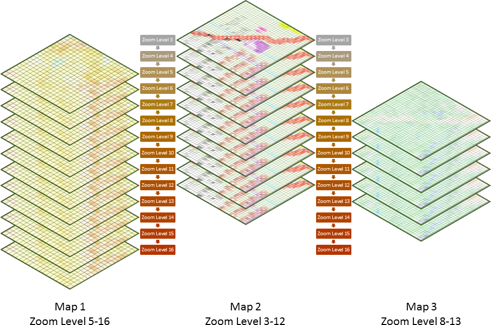
The HX-1 Explorer Mode and the Hema Explorer App both use "map layers" to define which maps are viewable at certain zoom levels.
Each map layer has a defined zoom range (ie. minimum and maximum zoom level), as detailed in the table below.
| Map Layer Name | Provider / Source | Minimum Zoom Level | Maximum Zoom Level | Approx. Max Scale |
|---|---|---|---|---|
| Hema Explorer | Hema | 5 | 16 * | 1:9000 |
| Cape York | Hema | 5 | 12 | 1:140,000 |
| Fraser Island | Hema | 8 | 15 | 1:18,000 |
| Great Desert Tracks (GDT) | Hema | 3 | 10 | 1:500,000 |
| The Kimberley | Hema | 5 | 10 | 1:500,000 |
| VIC High Country | Hema | 7 | 12 | 1:140,000 |
| HERE Terrain | HERE Maps | 0 | 17 | 1:4,500 |
| HERE Street | HERE Maps | 0 | 20 | 1:1,000 |
| HERE Satellite | HERE Maps | 0 | 17 | 1:4,500 |
| Geoscience 250k | Geoscience Australia | 5 | 12 | 1:240,000 |
| NSW Topo | NSW Government Land & Property | 5 | 19 | 1:1,100 |
| QLD Topo | QLD State Government | 5 | 15 | 1:18,000 |
| SA Topo | SA State Government / TopoDude | 4 | 15 | 1:18,000 |
| TAS Topo | State of Tasmania LIST | 5 | 18 | 1:2,200 |
| VIC Topo | VIC State Goverment / TopoDude | 5 | 15 | 1:18,000 |
* Hema Explorer can be accessed at a maximum zoom level of 12 in the Hema Explorer app. Purchasing a Pro subscription grants access to the maximum zoom level of 16.
Zoom levels roughly equate to a map scale, as per the table below.
| Zoom Level | Approximate Scale | Metres / Pixel | Zoom Level | Approximate Scale | Metres / Pixel |
|---|---|---|---|---|---|
| 0 | 1 : 500 million | 156,412 | 10 | 1 : 500,000 | 152.746 |
| 1 | 1 : 250 million | 78,206 | 11 | 1 : 250,000 | 76.373 |
| 2 | 1 : 150 million | 39,103 | 12 | 1 : 144,448 | 38.187 |
| 3 | 1 : 70 million | 19,551 | 13 | 1 : 72,224 | 19.093 |
| 4 | 1 : 35 million | 9,776 | 14 | 1 : 36,112 | 9.547 |
| 5 | 1 : 15 million | 4,888 | 15 | 1 : 18,056 | 4.773 |
| 6 | 1 : 10 million | 2,444 | 16 | 1 : 9,028 | 2.387 |
| 7 | 1 : 4 million | 1,222 | 17 | 1 : 4,514 | 1.193 |
| 8 | 1 : 2 million | 610.984 | 18 | 1 : 2,257 | 0.596 |
| 9 | 1 : 1 million | 305.492 | 19 | 1 : 1,128 | 0.298 |
Notice that each zoom level also equates to a number of metres per on-screen pixel. This means that different screens having different screen densities (numbers of pixels per inch on screen) may show different apparent scales. So you may have a 10" Android tablet, and a friend has another 10" Android tablet. If you compare the same map layer, with the same zoom level, you may see some difference in the way the map appears on screen.
The best way to think about map layers is to imagine a stack of paper maps piled one on top of the others.
Each map layer has a defined zoom level range, and not all maps cover all zoom levels.
If you switch on the Zoom Label under Settings, it will help you to know what your current zoom level is.
The Hema Maps layers should be downloaded after installing the app. Once downloaded, they are available for offline use.
If you tried to download map layers covering the whole of Australia, at all zoom levels, the amount of data is astronomical, and not feasible. If you want access to the map layers for a specific area, you should download that area for offline use while you have an internet connection. (ie. prior to leaving on your trip).