.png?width=128&height=72&name=Hema%20Maps%20Logo%20(1).png)
The Boiling Billy website at http://www.boilingbilly.net.au/ has free GPX files you can download which go with the Boiling Billy 4WD Treks series of books.
There is a downloadable ZIP file for each book.
Each download has individual treks split up into seperate folders etc.
Each trek GPX file contains a series of WAYPOINTS. If all you want to do is import these files into Hema Explorer as waypoints, then you can import them using the Cloud (http://cloud.hemaexplorer.com.au) Upload File feature
The only problem with this is that the upload file feature expects to see a GPX TRACK (or ROUTE) file, and NOT a file containing a bunch of waypoints.
If you want to use these files as a route within the Hema Explorer app, you need to do a bit of conversion work beforehand.
Here is what you need to do:
A GPX file is simply a text file with a specific format for specifying the following types of GPS information:
- Waypoints
- Tracks
- Routes
There are some useful tools available on the internet for free which you can use to manipulate GPX files, such as:
- GPSBabel (http://www.gpsbabel.org/) FREE/Donationware GPSBabel is a useful tool for converting GPS data from one format to another (for example OziExplorer Waypoints, to a GPX Route)
- GPS Track Editor (http://www.gpstrackeditor.com/) FREE GPS Track Editor is a nice tool for editing track logs in GPX format. (note it will only open files which contain valid TRACK data, not routes or waypoints - that's why it's called GPS TRACK Editor)
We are going to use GPSBabel in our little exercise here, so if you want to be able to do this, you will need to download and install GPSBabel on your PC from their website.
You will most likely have downloaded one or more of the Boiling Billy files from their website. They provide the data in ZIP files, so you will need to unzip the file(s) first.
A Bit About GPX files
GPX files are simply text files, so you can open them with any text editor like Notepad, or the freely available Notepad++.
Once the file(s) are unzipped, if you open one in Notepad, you will see something similar to the following (only part of the file is shown here, the center section has been removed to shorten the listing):
|
<?xml version="1.0" encoding="UTF-8" standalone="yes"?> . . . <desc>Fort Bribie</desc> |
As you can see, a GPX file is an XML file which contains specific tags containing the data. In some way it looks similar to an HTML file (a web page).
It is not important that you know what all the tags etc. are, but it is worth noting some of the structures you see here.
Most XML tags have an START and corresponding END tag. Most closing tags have the same name as the opening tag, but prefixed with a "/" to signify that they close that tag.
If you look at the listing, you will see that the file as a whole has an opening <gpx tag, and ends with a corresponding </gpx> tag.
There is an opening <metadata> tag, and a corresponding closing </metadata> tag.
Also, for each waypoint defined in this file, the waypoint data is enclosed within a <wpt> and </wpt> tag.
Converting a File From a GPX Waypoints File to a GPX Route File
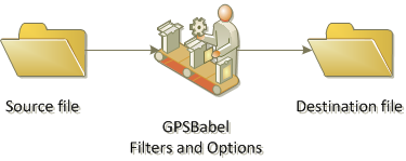
GPSBabel is designed to perform one function, which it does very well. That is, it is designed to take GPS data in one format, apply a bunch of changes to the file according to your specifications, and then create a new output file containing the original data which has been transformed by the changes you requested.
A simple diagram below shows the process.
Performing the actual conversion using GPSBabel
Start the GPSBabel program on your PC.
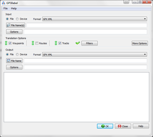
You will see the main GPSBabel window.
If you look at the window, you will see that it is divided up into several logical groups:
- The Input panel
- The Translation Options panel
- The Output panel
- The Results panel (displays information regarding what is happening)
This makes perfect sense, as these groupings define what GPSBabel does:
- Read the source file (Input)
- Make some changes to the format of the file (Translation)
- Write a new file with the transalation changes applied to the data from the input file (Output)
Basic Steps
These are the basic steps required to perform your conversion (more detail below in the step-by-step section). Once you have done these steps a few times, you will find it quite a simple task to convert your data between formats using GPSBabel.
- Select the Input Type
- Select the Input Format
- Select the Input File
- Specify any Filters or Options you wish to apply
- Select the Output Type
- Select the Output Format
- Select the Output File Name
- Start the conversion process
Almost all operations using GPSBabel follow the same basic steps.
Step-by-Step guide to converting (translating) a GPX File from Boiling Billy to a GPX Route file for use with Hema Explorer
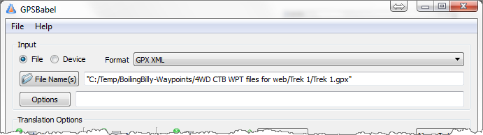
Set the Input type - File (File should be the default value)
Select the format for the input file from the drop-down list - GPX XML

Click the File Name(s) button and browse to where you have the source file stored on your PC.
There is no need to specify any additional input Options.
![]()

Click the Filters button in the Translation Options panel. The Data Filters window will open.
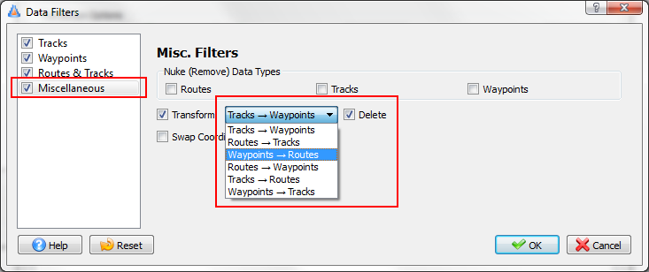
In the Data Filters window, click the Miscellaneous category in the column at the left.
Make sure the Transform option is ticked.
Click the dropdown-menu, and choose the Waypoint -> Routes option (remember, in this example, we are converting a file containing Waypoints to a Route file).
Make sure the Delete option is ticked. This makes sure that once we turn the waypoints in the source file into a route, we don't also leave the waypoints in there. Leave this option unticked if you do want to have a route AND waypoints in the output file.

Click the OK button to close the Data Filters window.
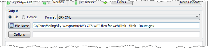
Set the Output type - File (File should be the default value)
Select the format for the output file from the drop-down list - GPX XML

Click the File Name button and browse to where you want to save the output file on your PC.
There is no need to specify any additional output Options.
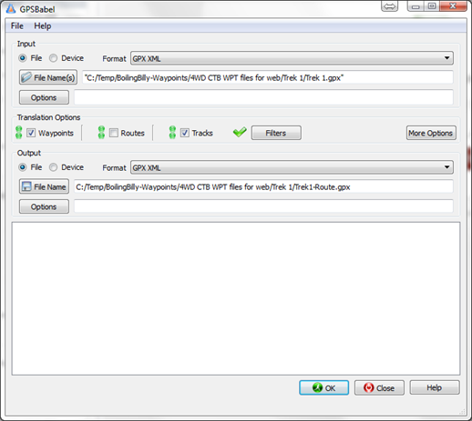
Once you have completed the steps above, GPSBabel is ready to roll.
The GPSBabel window should look like the example below.

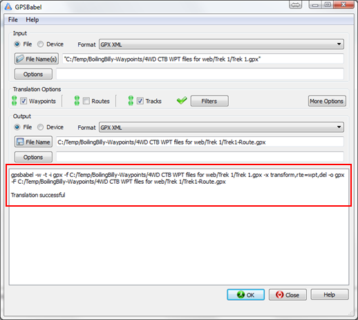
Click the OK button on the main GPSBabel window to start processing.
GPSBabel will read the input file, apply your filters and options, and create the output file. Messages will appear in the results panel at the bottom of the GPSBabel window.
After all the time it took you to setup, you may be surprised at how quickly GPSBabel processes your input file. Of course the time taken depends on what is in the input file. If you were converting a track log, for example, which contained tens of thousands of track points, you would expect it to take a lot longer than a file containing 50 waypoints.
Once processing is complete, the GPSBabel window should look similar to the following. Notice that the results panel shows a message at the bottom saying the translation was successful.
Once the file has been converted, if you open it in Notepad, you will see something similar to the following (only part of the file is shown here, the center section has been removed to shorten the listing):
|
<?xml version="1.0" encoding="UTF-8"?> . . </rte> |
As you can see, the GPX file now contains different tags to those in the source file.
There are now <rte> and </rte> tags which enclose the Route definition.
Each point which makes up the route is defined by the tag pair of <rtept> and </rtept>.

After verifying that your file has been converted successfully, you can exit out of GPSBabel by clicking the Close button.
As you now have a usable GPX route file, you can do one of the following:
- Copy the GPX route file directly to your device by connecting it via USB cable to your PC. Then use the Import file function to load the Route file into Hema Explorer.
- Use the Upload function on the Cloud website to load your Route to your Cloud account at http://cloud.hemaexplorer.com.au/
You might wonder why we don't just convert all the files and post them here. There's a couple of reasons:
- It might infringe Boiling Billy's copyright
- Boiling Billy may make changes to some or all of the files which means they'd all have to be converted again
- It's better to learn how to do some of this stuff yourself; as it's useful knowledge to have, and that's part of the fun!